Exam Code: EADE105
Exam Name: ArcGIS Desktop Entry 10.5
Certification Provider: Esri
Corresponding Certification: EADE
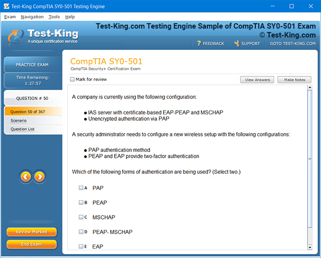
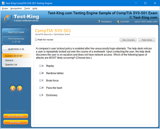
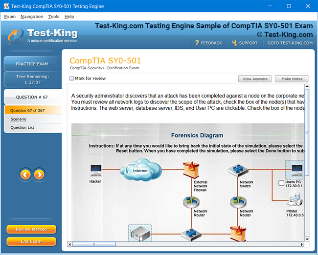
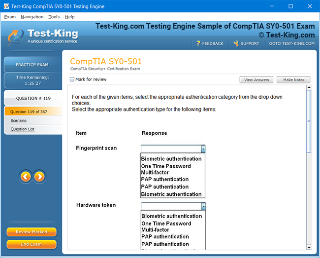
Product Screenshots

Frequently Asked Questions
How can I get the products after purchase?
All products are available for download immediately from your Member's Area. Once you have made the payment, you will be transferred to Member's Area where you can login and download the products you have purchased to your computer.
How long can I use my product? Will it be valid forever?
Test-King products have a validity of 90 days from the date of purchase. This means that any updates to the products, including but not limited to new questions, or updates and changes by our editing team, will be automatically downloaded on to computer to make sure that you get latest exam prep materials during those 90 days.
Can I renew my product if when it's expired?
Yes, when the 90 days of your product validity are over, you have the option of renewing your expired products with a 30% discount. This can be done in your Member's Area.
Please note that you will not be able to use the product after it has expired if you don't renew it.
How often are the questions updated?
We always try to provide the latest pool of questions, Updates in the questions depend on the changes in actual pool of questions by different vendors. As soon as we know about the change in the exam question pool we try our best to update the products as fast as possible.
How many computers I can download Test-King software on?
You can download the Test-King products on the maximum number of 2 (two) computers or devices. If you need to use the software on more than two machines, you can purchase this option separately. Please email support@test-king.com if you need to use more than 5 (five) computers.
What is a PDF Version?
PDF Version is a pdf document of Questions & Answers product. The document file has standart .pdf format, which can be easily read by any pdf reader application like Adobe Acrobat Reader, Foxit Reader, OpenOffice, Google Docs and many others.
Can I purchase PDF Version without the Testing Engine?
PDF Version cannot be purchased separately. It is only available as an add-on to main Question & Answer Testing Engine product.
What operating systems are supported by your Testing Engine software?
Our testing engine is supported by Windows. Andriod and IOS software is currently under development.
Free and Paid Learning Paths to Ace the ArcGIS Desktop Entry 10.5 (EADE105) Exam
The ArcGIS Desktop Entry 10.5 certification, officially identified by the exam code EADE105, serves as a gateway for individuals aspiring to establish their foundation in geographic information systems under the guidance of Esri. This certification exam is not merely a test of technical proficiency; it is a measure of conceptual clarity, analytical reasoning, and the ability to apply spatial data management principles within a practical framework. Those who seek to embark on this certification path often begin their journey from diverse academic and professional backgrounds, united by their curiosity about spatial analysis, digital cartography, and geospatial problem-solving.
Understanding the ArcGIS Desktop Entry 10.5 Certification Landscape
At its core, the EADE105 examination assesses an individual’s competence in utilizing ArcGIS Desktop tools for tasks such as data organization, visualization, mapping, and spatial analysis. The certification validates entry-level understanding, making it ideal for students, early-career professionals, and even seasoned field technicians who wish to formalize their GIS expertise under Esri’s globally recognized standards. The allure of this certification lies in its equilibrium between accessibility and intellectual rigor—it welcomes newcomers while maintaining a level of sophistication that rewards disciplined study.
To achieve mastery over ArcGIS Desktop Entry 10.5, one must first comprehend the multifaceted structure of the ArcGIS ecosystem itself. ArcGIS Desktop, as a platform, is a constellation of applications such as ArcMap, ArcCatalog, and ArcToolbox, each orchestrating distinct yet interconnected operations. ArcMap forms the visual and analytical centerpiece, allowing users to craft maps, perform spatial queries, and execute geoprocessing tools. ArcCatalog serves as the organizational nucleus, where datasets, shapefiles, rasters, and geodatabases are managed with precision. ArcToolbox functions as a repository of specialized geoprocessing functions that empower the analyst to manipulate, analyze, and model spatial information. Understanding the interplay between these components is not just advantageous for the EADE105 exam but forms the intellectual spine of GIS practice in general.
The conceptual territory examined within EADE105 spans from the rudiments of geographic data structures to the implementation of geoprocessing workflows. The candidate must exhibit fluency in identifying spatial data types such as vector and raster, recognize coordinate systems and projections, perform basic data editing, and design maps that convey information effectively. Beyond the mechanical operations, however, lies an expectation of cognitive agility—understanding why certain tools are used, how spatial relationships are modeled, and what analytical insights can be extracted from patterns on the map.
Free and paid learning pathways converge at this point, offering diverse routes toward proficiency. Some aspirants prefer open-source educational materials and community-driven tutorials, while others pursue structured instruction through Esri’s official learning programs or accredited GIS academies. The choice between these options depends largely on individual learning preferences, available time, and the depth of expertise one wishes to attain.
The free learning resources available for EADE105 preparation can be unexpectedly rich in content. Esri’s own training platform provides complimentary introductory courses such as “Getting Started with GIS” and “Exploring ArcGIS Desktop,” both of which serve as conceptual springboards into the more advanced competencies required by the certification exam. These self-paced modules are carefully curated to develop familiarity with ArcGIS interfaces, tool functionalities, and workflow design principles. Complementing Esri’s offerings are numerous academic repositories, open courseware platforms, and university-led GIS programs that provide open-access study materials, video lectures, and reading lists.
Community forums like GeoNet, Stack Exchange, and GIS Stack Overflow also act as informal learning environments where aspiring candidates can engage in dialogues with experienced practitioners. These forums become invaluable when dealing with nuanced topics such as data projection conflicts, topology errors, or the application of geoprocessing models. The ability to articulate a problem, seek advice, and integrate community insights forms an often-overlooked dimension of learning that strengthens conceptual maturity.
However, while free resources serve as indispensable foundations, paid pathways offer a structured and meticulously guided approach that many learners find essential for exam readiness. Esri’s paid instructor-led courses are designed to mirror the skill areas measured by the EADE105 exam blueprint. For instance, courses like “ArcGIS Desktop Fundamentals” and “Spatial Analysis with ArcGIS Pro” integrate conceptual theory with hands-on exercises that simulate real-world scenarios. These courses are frequently accompanied by practice datasets, case studies, and guided assessments, which help candidates internalize GIS operations beyond rote memorization.
Universities and specialized GIS academies also curate certification preparation programs that blend theoretical instruction with practical application. Students enrolled in such programs gain exposure to the broader philosophical context of geospatial science—understanding how geographic data informs decision-making across environmental management, urban planning, disaster response, and business intelligence. In this sense, the EADE105 certification acts as an intellectual threshold that introduces learners to a discipline that bridges science, technology, and spatial reasoning.
An important element of preparation involves understanding how ArcGIS Desktop Entry 10.5 fits into the continuum of Esri’s certification hierarchy. This credential represents the foundational level within Esri’s broader certification framework, preceding intermediate and professional certifications like ArcGIS Desktop Associate and ArcGIS Desktop Professional. Therefore, a learner who masters the EADE105 competencies not only gains recognition as an entry-level GIS specialist but also establishes the groundwork for future specialization in advanced spatial analysis, database management, and enterprise GIS solutions.
To develop a balanced learning strategy, one must weave together both conceptual learning and hands-on experimentation. ArcGIS software itself provides a fertile environment for such experiential learning. By engaging with sample datasets—such as city zoning layers, elevation models, and demographic shapefiles—learners can experiment with map symbology, query functions, and spatial joins. This tactile engagement with data transforms abstract knowledge into practical skill. Those who adopt a daily practice routine within ArcMap or ArcGIS Pro quickly acquire the reflexes necessary for efficient tool use during the exam’s performance-based tasks.
A crucial aspect of EADE105 readiness is understanding data integrity and geodatabase management. In GIS, the accuracy of results is inherently tied to the quality of the data being used. The candidate must understand how to create, edit, and maintain geodatabases, manage attribute fields, and enforce topology rules to ensure spatial consistency. Learning platforms—whether free or paid—must therefore provide exercises that simulate these operations. A comprehensive understanding of data validation, coordinate transformations, and metadata documentation is a distinguishing trait of well-prepared candidates.
Map design, often underestimated by beginners, forms another vital dimension of the EADE105 examination. Esri emphasizes cartographic principles such as visual hierarchy, symbolization, labeling, and layout composition. The ability to design a map that communicates purpose, audience, and data accuracy is a hallmark of a competent GIS professional. Free resources, such as the Esri Map Design eBook and various cartography tutorials available through academic portals, can be instrumental in cultivating this aesthetic and functional understanding. Paid programs tend to integrate map design exercises into their curriculum, ensuring that candidates can transition seamlessly from data processing to effective visual presentation.
In addition to map creation, the candidate must grasp the basics of spatial analysis. The EADE105 exam may require the interpretation of analytical results, such as buffer zones, overlays, or statistical summaries. These analytical techniques rely on a conceptual understanding of spatial relationships—knowing how proximity, containment, or adjacency can reveal patterns otherwise hidden in raw data. Free learning materials available through Esri’s Learn ArcGIS platform offer guided lessons that walk learners through such analyses step-by-step. Paid courses, on the other hand, extend these exercises into more complex modeling scenarios, introducing candidates to advanced geoprocessing workflows that cultivate analytical fluency.
The interplay between free and paid resources can be compared to the balance between exploration and discipline. Free learning materials encourage curiosity and self-direction; they invite the learner to wander through the conceptual landscape of GIS at their own pace, exploring areas of personal interest. Paid programs impose structure, offering milestones, feedback, and progression tracking. The ideal preparation journey for EADE105 often involves a synthesis of both. A learner might begin with Esri’s free introductory courses, engage in community-based problem solving, and later enroll in an instructor-led paid course for focused skill refinement.
Esri’s Learning ArcGIS Pro initiative, although geared toward a newer interface than ArcMap, remains relevant to EADE105 preparation because the underlying GIS principles remain consistent. Many candidates find that learning through ArcGIS Pro enriches their understanding of spatial workflows even when the exam’s focus is primarily on ArcMap. Furthermore, Esri’s educational ecosystem provides a seamless transition between these environments, enabling learners to apply the same analytical logic across different interfaces.
Beyond Esri’s ecosystem, several online educational platforms host comprehensive GIS training programs. Websites such as Coursera, Udemy, and LinkedIn Learning collaborate with GIS professionals and academic institutions to deliver courses that align closely with the EADE105 objectives. These courses often combine theoretical explanations with practical demonstrations, and they include quizzes and assignments that mirror real-world GIS tasks. The inclusion of case studies—ranging from environmental conservation mapping to urban infrastructure analysis—helps learners see the tangible relevance of the skills they acquire.
An additional yet often overlooked dimension of preparation lies in developing familiarity with Esri’s terminology and documentation style. The official Esri documentation, which details tool descriptions, parameters, and usage examples, represents one of the most authoritative sources of knowledge for candidates. Regularly consulting this documentation helps aspirants internalize the precise vocabulary used in GIS, thereby improving comprehension during the exam. Understanding how Esri defines terms such as “feature class,” “geodatabase,” “layer file,” and “spatial index” is critical for accurate interpretation of exam questions.
Another pivotal factor in effective preparation is time management. The EADE105 exam, like many professional certification assessments, evaluates not only knowledge but also efficiency. Candidates must be able to navigate the ArcGIS interface, locate tools quickly, and perform operations within limited time. Developing such fluency requires consistent practice sessions that mimic exam-like conditions. By setting time limits on exercises—such as completing a map layout or executing a spatial join—learners can condition their workflow to operate with both accuracy and speed.
Understanding the theoretical framework behind coordinate systems and projections is also indispensable. Spatial data often originates from disparate sources, each potentially defined in a different coordinate reference system. Misalignment of datasets due to projection inconsistencies is a common pitfall for novice users. Therefore, aspirants must learn how to identify projection information, reproject datasets appropriately, and maintain spatial coherence across layers. Free online materials, including university tutorials and Esri’s Coordinate Systems Guide, provide concise yet powerful instruction in this domain. Paid courses often complement this knowledge with hands-on laboratory exercises that solidify comprehension through repetition.
Furthermore, proficiency in attribute data management stands as a pillar of GIS competence. Candidates must understand how to construct and manipulate attribute tables, perform field calculations, and design queries that extract meaningful information. This skill transcends the exam’s requirements, forming a cornerstone of all GIS applications in professional environments. Through self-guided practice or structured coursework, learners should cultivate dexterity in sorting, joining, and analyzing attribute data, as these operations are ubiquitous in spatial analysis workflows.
While much emphasis is placed on technical skills, conceptual thinking should not be neglected. The EADE105 exam requires an understanding of GIS not merely as software but as a system for managing spatial knowledge. This means appreciating the relationship between data, processes, and outcomes. It means recognizing how geographic information supports decision-making in governance, conservation, and commerce. Candidates who approach their preparation with this broader awareness tend to develop a deeper, more durable understanding of GIS principles, enabling them to adapt to new technologies and methodologies beyond ArcGIS Desktop 10.5 itself.
As learners progress, it becomes vital to simulate the conditions of the certification exam. Esri provides sample question sets that reflect the style, structure, and complexity of the actual EADE105 exam. Working through these examples allows candidates to identify areas of weakness and reinforce their understanding through targeted revision. Although these samples do not replicate the full exam experience, they cultivate familiarity with the phrasing and logic used in Esri’s questioning methodology. Paid preparation courses often integrate mock exams that provide a closer approximation of the real testing environment, enhancing readiness through experiential learning.
To maintain motivation throughout the preparation journey, learners should adopt a reflective learning approach. Keeping a study journal that records daily progress, challenges encountered, and insights gained helps solidify learning and maintain momentum. The process of articulating what one has learned each day reinforces memory retention and fosters a sense of intellectual continuity. Online study groups or mentorship arrangements can further amplify this process by introducing accountability and collaborative engagement.
Ultimately, the path toward mastering ArcGIS Desktop Entry 10.5 is as much about cultivating analytical disposition as it is about accumulating information. The EADE105 exam rewards precision, reasoning, and adaptability—qualities that emerge through consistent practice, thoughtful study, and exposure to diverse spatial problems. Whether one’s learning pathway leans toward free community-based resources or structured paid training programs, the essential goal remains constant: to internalize the logic of spatial thinking and apply it effectively within the ArcGIS environment.
Exploring Comprehensive Study Frameworks for Mastery
The endeavor to attain proficiency in ArcGIS Desktop Entry 10.5, represented by the Esri certification examination EADE105, is a quest that transcends rote memorization and superficial tool familiarity. It demands immersion into the philosophical and technical intricacies of geographic information systems and a recognition of the dynamic relationship between spatial thinking and technological application. For many aspirants, this journey becomes an intersection of intellectual curiosity, disciplined study, and purposeful exploration. The certification represents not only the mastery of a software environment but the assimilation of a spatially oriented worldview.
In preparing for this certification, understanding the structural essence of the ArcGIS Desktop suite is essential. ArcGIS Desktop 10.5 is an integrated system composed of applications such as ArcMap, ArcCatalog, ArcGlobe, and ArcScene, each serving specialized yet interconnected functions within the Esri ecosystem. ArcMap facilitates map creation, spatial analysis, and data visualization. ArcCatalog functions as the archive and organizational repository of spatial datasets, geodatabases, and metadata. ArcGlobe and ArcScene extend this environment into three-dimensional visualization, enabling analysts to perceive topography, elevation, and other surface characteristics through a multidimensional lens. To achieve mastery over these components is to develop a holistic awareness of spatial reasoning, geoprocessing, and data representation.
A structured learning framework begins with the comprehension of the EADE105 exam blueprint, which outlines the knowledge domains and cognitive expectations of the candidate. The exam evaluates competency across areas such as understanding GIS concepts, managing data, producing and sharing maps, conducting analysis, and applying ArcGIS tools effectively. Each of these domains requires both theoretical comprehension and experiential engagement. Candidates who internalize the underlying logic of spatial relationships are better equipped to navigate the subtle complexities embedded in the test’s practical scenarios.
The realm of free educational resources offers fertile ground for preliminary exploration. Esri’s official Learn ArcGIS platform provides self-guided lessons that replicate authentic spatial analysis challenges. For instance, learners might engage in exercises involving the mapping of natural hazards, the analysis of urban expansion, or the assessment of transportation accessibility. These exercises are structured around real-world problems, thereby grounding theoretical principles in applied contexts. Free courses such as “Fundamentals of GIS” and “Mapping and Visualization with ArcGIS” expose learners to essential operations—layer management, symbology design, spatial querying, and attribute manipulation—while cultivating a broader understanding of the software’s logic.
Complementing Esri’s own materials are open-access university resources and governmental GIS portals, which disseminate tutorials, datasets, and manuals tailored for foundational learners. Institutions such as MIT, Penn State, and UNIGIS host publicly accessible courses that encompass the same intellectual terrain as the EADE105 competencies. These resources encourage learners to explore the conceptual substratum of GIS, such as data abstraction, georeferencing, coordinate transformations, and thematic mapping. The open nature of such materials fosters academic inclusivity, allowing anyone with an internet connection to build the scaffolding of their GIS expertise without incurring financial cost.
Despite the abundance of open-access material, structured paid learning continues to hold profound value for aspirants who seek directed progression. Esri’s instructor-led courses provide a meticulously sequenced approach to ArcGIS proficiency, combining lectures, demonstrations, and supervised practical exercises. These courses emphasize not only the procedural aspects of GIS but also the interpretive dimension—the ability to infer meaning from spatial data. Participants are encouraged to develop analytical independence while being guided through workflows that mirror the real-world applications of GIS in government, environmental science, and business.
Paid e-learning programs also offer comprehensive preparation for the EADE105 exam. Many of these programs are designed by GIS professionals who align their curricula with Esri’s certification standards. Students benefit from curated exercises, access to proprietary datasets, and instructor feedback that helps correct conceptual misunderstandings before they solidify into habits. Furthermore, subscription-based learning platforms often grant learners extended access to ArcGIS software licenses, enabling uninterrupted hands-on practice throughout the preparation period. This accessibility is particularly advantageous for those without institutional affiliations or workplace licenses.
A distinctive advantage of paid programs lies in their integration of project-based learning. Rather than simply following scripted tutorials, students are invited to construct original GIS projects that simulate the complexities of professional spatial analysis. For example, one might design a study analyzing regional vegetation patterns, urban sprawl, or transportation equity. These projects demand that learners synthesize multiple skills—data acquisition, spatial processing, map design, and result interpretation—into coherent workflows. Such integrative exercises enhance cognitive depth and reinforce the competencies required for the EADE105 examination.
However, whether one pursues free or paid learning avenues, the essence of effective preparation remains consistency and reflection. Candidates should cultivate a disciplined study routine that blends theoretical reading with active experimentation. It is not sufficient to passively consume tutorials; one must continually challenge themselves to recreate processes from memory, test alternative tool configurations, and critique their outputs. This iterative cycle of practice and introspection is what transforms a learner into a practitioner capable of independent problem-solving.
A comprehensive understanding of data models is indispensable for success in ArcGIS Desktop Entry 10.5. Esri’s framework distinguishes between vector and raster data, each representing spatial phenomena through unique structural paradigms. Vector data models the world through discrete geometries—points, lines, and polygons—each associated with attributes stored in tabular format. Raster data, by contrast, represents continuous surfaces through a grid of cells, each encoded with a numerical value corresponding to a spatial property such as elevation or temperature. Understanding when and why to employ each model is critical for analytical precision. The EADE105 exam often requires recognition of these distinctions, as well as familiarity with conversion methods that translate data between formats.
Equally important is the comprehension of coordinate systems and projections, a conceptual territory that often challenges even seasoned GIS users. The Earth’s curvature necessitates the translation of three-dimensional geography onto two-dimensional maps, a process that introduces distortion in area, distance, or shape. Esri’s coordinate system tools within ArcMap and ArcCatalog enable users to define, project, and transform datasets to ensure spatial alignment. Learners preparing for EADE105 must be able to recognize the implications of projection choices, manage on-the-fly reprojection, and interpret coordinate metadata embedded within spatial files.
Data integrity and geodatabase management also occupy a central role in the exam’s conceptual framework. The geodatabase serves as the structural heart of ArcGIS, providing a controlled environment for storing, editing, and validating spatial data. Candidates must understand how to create and maintain feature classes, establish attribute domains, enforce topology rules, and maintain metadata consistency. Exercises that involve correcting topological errors, defining subtypes, or applying validation rules are invaluable in building the spatial discipline expected by Esri’s evaluative standards.
Cartography forms another domain that transcends aesthetic design to embody the communicative essence of GIS. ArcGIS Desktop Entry 10.5 equips users with symbology options, labeling tools, and layout templates that facilitate the construction of maps that are not only visually appealing but semantically precise. Learners must grasp the principles of visual hierarchy, color theory, and scale dependency. The ability to produce a map that effectively conveys data patterns, supports analytical arguments, and meets audience expectations demonstrates mastery beyond mechanical operation. Free tutorials available through Esri’s cartographic resources and independent GIS educators can refine this skill, while paid programs often provide feedback on design decisions to help learners achieve professional-level map quality.
Spatial analysis—the core intellectual function of GIS—is the most conceptually demanding domain within the EADE105 certification. It encompasses the processes through which spatial relationships are quantified and interpreted. Candidates must understand how to use proximity tools to delineate buffer zones, overlay tools to identify intersecting features, and statistical tools to summarize patterns across geographic extents. The true challenge lies not in executing these tools mechanically but in discerning which analytical technique is most appropriate for a given spatial problem. To cultivate this discernment, learners should engage with diverse datasets and experiment with multiple analytical approaches to compare outcomes.
Temporal and thematic analysis adds further depth to GIS operations. By integrating time-enabled layers and attribute data, ArcGIS Desktop allows analysts to visualize change across temporal intervals. Understanding how to construct time series animations, manage date fields, and interpret evolving spatial phenomena provides a competitive edge in the exam. Free Esri lessons on temporal mapping and dynamic visualization offer accessible introductions to this topic, while paid advanced courses provide case studies involving land use change, climate modeling, and urban development monitoring.
Another dimension of EADE105 preparation lies in mastering data acquisition and conversion techniques. GIS professionals often integrate data from diverse sources—satellite imagery, GPS surveys, shapefiles, and online web services. Candidates should be adept at importing, converting, and harmonizing these datasets into the ArcGIS environment. The ability to troubleshoot data inconsistencies, resolve missing coordinate references, and clean attribute tables reflects a mature understanding of data stewardship. Exercises involving shapefile repair, field calculation, and reclassification build resilience and adaptability in handling heterogeneous spatial data.
As learners progress through their study journey, the cultivation of digital literacy becomes increasingly significant. ArcGIS Desktop 10.5 operates within a broader ecosystem that includes ArcGIS Online, ArcGIS Pro, and various extensions. Understanding how these components interrelate enriches the candidate’s conceptual framework. For instance, familiarity with ArcGIS Online enhances comprehension of data sharing, cloud-based mapping, and collaborative project management. Exposure to ArcGIS Pro introduces modernized workflows and reinforces the continuity of GIS principles across software versions. Even though the EADE105 exam focuses on ArcGIS Desktop, the transferable nature of GIS knowledge ensures that broader exploration benefits overall mastery.
To navigate the cognitive demands of the certification process, learners must adopt metacognitive strategies that enhance retention and comprehension. Concept mapping, spaced repetition, and retrieval practice are powerful techniques for consolidating GIS knowledge. By visually mapping relationships between data models, coordinate systems, and analysis tools, candidates reinforce their mental schema of the ArcGIS framework. Regular self-testing—through quizzes, flashcards, or mock exercises—promotes active recall and highlights conceptual gaps. This systematic reinforcement ensures that understanding becomes durable and retrievable under the time constraints of the EADE105 exam.
Equally valuable is the practice of integrating GIS learning with domain-specific contexts. The versatility of ArcGIS allows its principles to be applied across diverse disciplines—from environmental science to urban planning, from archaeology to epidemiology. By contextualizing learning within an area of personal or professional interest, candidates create meaningful cognitive anchors that facilitate memory retention. A student studying environmental systems might explore hydrological modeling or land cover classification, while one interested in business analytics might examine demographic segmentation or logistics optimization. This contextual immersion transforms GIS learning from an abstract endeavor into a purposeful pursuit.
Collaboration and community engagement amplify learning outcomes. The Esri GeoNet community and GIS Stack Exchange serve as digital salons where practitioners exchange ideas, troubleshoot issues, and share innovative workflows. Participating in these forums not only provides technical insight but also exposes learners to the diversity of GIS applications worldwide. Engaging with peers fosters intellectual camaraderie and reinforces the collaborative ethos of the GIS profession. Candidates who immerse themselves in such networks often gain exposure to emerging methodologies, alternative problem-solving approaches, and professional opportunities.
While cognitive preparation is paramount, practical familiarity with the software environment is equally indispensable. The EADE105 exam requires navigation efficiency and tool recognition that can only be developed through habitual engagement. Candidates should dedicate regular intervals to practicing with ArcMap and ArcCatalog, exploring toolboxes, experimenting with geoprocessing models, and customizing the interface to suit their workflow. Familiarity with data management shortcuts, context menus, and tool parameters transforms the user experience from tentative exploration into confident command.
Documentation literacy further refines this proficiency. Esri’s online help resources constitute an expansive library detailing every tool, parameter, and data type within ArcGIS Desktop. Learners who consult these documents regularly develop an instinctive understanding of tool behavior and dependencies. This awareness proves invaluable when encountering complex exam questions that hinge on nuanced distinctions between similar tools or parameter settings. Cultivating the habit of referencing documentation ensures that learning remains precise, authoritative, and aligned with Esri’s terminology.
The psychological dimension of preparation should not be underestimated. The EADE105 certification, while introductory in level, represents a significant intellectual milestone for many candidates. Managing test anxiety, maintaining focus, and sustaining motivation across the study period are essential aspects of success. Techniques such as goal segmentation, mindfulness, and balanced scheduling contribute to cognitive resilience. Learners should set incremental milestones—completing specific tutorials, mastering data management workflows, or producing a polished map project—to maintain a sense of progress and accomplishment.
In the broader context of professional development, the ArcGIS Desktop Entry 10.5 certification functions as a credential that validates spatial literacy and technological competence. Employers across government agencies, research institutions, and private enterprises recognize Esri certifications as benchmarks of GIS proficiency. Possession of this credential signifies an individual’s ability to interpret geographic data, construct spatial solutions, and contribute to evidence-based decision-making. For early-career professionals, it often serves as a catalyst for advancement into specialized GIS roles or as a foundation for pursuing higher-level certifications.
The ultimate measure of readiness lies not merely in the number of hours studied but in the synthesis of conceptual understanding, practical fluency, and analytical intuition. Candidates who integrate free and paid learning resources achieve a balance between independence and guidance, exploration and structure. Through deliberate practice, reflective learning, and engagement with the GIS community, they cultivate the competencies that Esri seeks to certify through the EADE105 examination. The pursuit of this certification thus becomes not only a professional qualification but a transformative educational experience that reshapes the learner’s perception of space, data, and the interconnected world around them.
Building Conceptual Depth and Spatial Intuition for Proficiency
The pursuit of mastery in the ArcGIS Desktop Entry 10.5 certification, encapsulated in the Esri exam code EADE105, requires an alignment of intellect, discipline, and curiosity. It is an endeavor that goes beyond technical precision and enters the realm of spatial reasoning and geographical literacy. The certification stands not simply as an acknowledgment of skill but as a reflection of the learner’s ability to interpret and interact with the spatial dimension of the world. This cognitive evolution begins with the cultivation of conceptual understanding—the invisible architecture upon which every technical action rests.
For any learner aspiring to achieve excellence in EADE105, the first essential task is to internalize the meaning of geographic information systems as an epistemological framework rather than as a mere software suite. GIS embodies a philosophy of spatial awareness, where every layer, coordinate, and feature narrates a portion of the Earth’s story. ArcGIS Desktop 10.5, through its multifaceted applications such as ArcMap, ArcCatalog, and ArcToolbox, functions as the intellectual laboratory where this philosophy is transformed into tangible analysis. To comprehend this transformation, one must understand the anatomy of spatial data—how information is structured, stored, and symbolized to render patterns perceptible.
The ArcGIS Desktop Entry 10.5 certification tests precisely this interplay between conceptual comprehension and operational fluency. A well-prepared candidate is not only able to execute a buffer or overlay operation but understands the geospatial reasoning that justifies its use. This form of reasoning emerges through the continuous synthesis of three dimensions: the data model, the analytical process, and the interpretative outcome. Mastery of these dimensions is best achieved through a learning pathway that combines theoretical study with applied experimentation, guided by both free and paid educational resources.
Free educational pathways continue to serve as the intellectual foundation for many candidates. Esri’s extensive repository of open-access lessons enables learners to explore the mechanics of ArcGIS Desktop 10.5 through self-paced, scenario-based activities. For instance, exercises involving demographic mapping or natural resource monitoring introduce learners to the subtleties of symbology, data classification, and thematic design. These lessons simulate real-world challenges while embedding the procedural knowledge required for the EADE105 examination. Supplementary free materials from universities and online GIS communities enrich this foundation by introducing learners to conceptual topics such as coordinate geometry, data integrity, and spatial data infrastructures.
However, free learning resources, while abundant, often demand a high degree of self-direction. The learner must design their own progression, identify gaps in understanding, and independently curate a study schedule. In contrast, paid educational programs introduce deliberate structure and cumulative pedagogy. Esri’s instructor-led training courses and certification-aligned learning plans are meticulously calibrated to reflect the EADE105 competency domains. Learners in such programs benefit from expert guidance, curated datasets, and practical feedback, which collectively accelerate comprehension. Paid programs often simulate exam scenarios by integrating time-bound exercises, performance reviews, and conceptual quizzes that mirror the style and phrasing of actual Esri assessments.
The intellectual rigor of the ArcGIS Desktop Entry 10.5 exam stems from its holistic evaluation of a candidate’s spatial literacy. The assessment does not isolate operations but contextualizes them within realistic geospatial workflows. For instance, a question may require a candidate to identify which projection system preserves area accuracy for a thematic analysis, or to determine the most appropriate tool for evaluating the overlap between environmental zones. Such questions test not only operational memory but inferential reasoning. To cultivate this capacity, learners must engage with a diverse array of spatial problems during their study period.
A powerful strategy for deep learning involves constructing personal GIS projects that replicate professional analytical challenges. By selecting a topic of genuine interest—such as urban heat mapping, watershed delineation, or agricultural zoning—candidates can weave together multiple competencies tested in EADE105. The process of collecting spatial data, verifying coordinate integrity, performing spatial joins, and visualizing the final output reinforces comprehension at a molecular level. The iterative refinement of these projects mirrors the analytical precision expected in professional GIS practice, transforming theoretical understanding into operational dexterity.
Spatial data management remains the structural pillar of the certification. Within ArcGIS Desktop, the ability to organize, edit, and validate datasets within a geodatabase framework reflects a candidate’s understanding of spatial governance. A geodatabase is not a passive storage system but an intelligent container capable of enforcing topology rules, attribute domains, and relationships among features. Mastery of this environment demands familiarity with geodatabase creation, subtype definition, and schema maintenance. Exercises that simulate data editing and validation develop the intuition required to maintain data integrity across projects—a concept that Esri regards as fundamental to professional GIS standards.
The ArcGIS Desktop Entry 10.5 environment also challenges learners to navigate the subtle intricacies of coordinate systems and projections. A misaligned dataset can lead to analytical inaccuracies that compromise entire studies. The ability to identify projection metadata, apply geographic transformations, and harmonize datasets from different coordinate systems is a non-negotiable skill. Understanding the mathematical essence of map projections—how the curvature of the Earth is transcribed onto a flat plane—is vital for interpreting the spatial coherence of map layers. Candidates who cultivate a conceptual familiarity with projection families such as conformal, equal-area, and equidistant projections find themselves well equipped to handle exam scenarios that test spatial accuracy.
Map design constitutes another critical dimension of the EADE105 evaluation. The aesthetic and communicative elements of cartography converge here to form a test of clarity and visual storytelling. Esri expects candidates to exhibit proficiency in symbolization, annotation, labeling, and layout composition. Beyond the mechanical selection of colors or line styles lies a deeper requirement: the ability to design maps that convey meaning with immediacy and precision. Effective cartography balances artistic sensibility with analytical transparency. Learners should thus dedicate time to studying map design principles, understanding how scale, color contrast, and typographic hierarchy influence interpretation. Both free tutorials and structured paid workshops on cartography can sharpen this dimension of expertise.
Spatial analysis, the analytical nucleus of GIS, integrates all preceding concepts into a dynamic problem-solving process. ArcGIS Desktop 10.5 provides a vast suite of geoprocessing tools that enable users to interrogate spatial relationships. Tools such as buffer, intersect, union, dissolve, and clip serve as the vocabulary of spatial reasoning. The challenge lies in selecting the correct tool for a given analytical objective. Candidates should therefore cultivate an understanding of geoprocessing logic—how inputs, parameters, and outputs interact to generate meaningful spatial insights. Beyond mere familiarity, fluency in combining tools through model building or sequential analysis reflects the depth of spatial intuition that the EADE105 exam implicitly measures.
An often-overlooked yet essential component of preparation involves mastering attribute data manipulation. The attribute table is the narrative companion to spatial geometry, storing the descriptive properties that render features interpretable. Candidates must know how to perform field calculations, sort and query records, and join tables using relational logic. Such operations transform raw data into analytical intelligence. The ability to formulate and execute SQL-based queries within ArcGIS Desktop allows candidates to distill large datasets into precise subsets, a skill indispensable in both examination and real-world contexts.
The proficiency demanded by the EADE105 exam extends beyond desktop mechanics into the domain of spatial data ethics and stewardship. Esri’s educational philosophy emphasizes responsible data use, accuracy verification, and metadata documentation. A competent GIS professional must ensure that spatial representations are truthful, reproducible, and contextually appropriate. Learners preparing for the certification should thus develop an awareness of data provenance, licensing, and ethical mapping practices. This awareness aligns with Esri’s broader vision of promoting geospatial literacy that serves society responsibly.
In terms of study strategy, candidates benefit from adopting a cyclical approach to learning that alternates between conceptual study, applied practice, and reflective review. Conceptual study involves reading documentation, watching instructional videos, and exploring theoretical principles. Applied practice requires implementing those concepts in ArcGIS Desktop through exercises or independent projects. Reflective review entails evaluating one’s outputs, identifying errors, and articulating the rationale behind successful outcomes. This iterative cycle of learning mirrors the recursive nature of GIS itself—an ongoing dialogue between theory and practice.
To maintain cognitive resilience throughout this demanding process, learners should employ memory reinforcement techniques. Spaced repetition, whereby topics are revisited at expanding intervals, enhances long-term retention. Visual learning aids such as conceptual diagrams and process flowcharts help embed procedural knowledge. Descriptive journaling, where one documents the logic behind analytical decisions, cultivates metacognitive awareness. Over time, these practices refine not only the retention of facts but the agility of thought required to solve unfamiliar problems during the EADE105 examination.
The modern GIS ecosystem, while centered on ArcGIS Desktop 10.5, extends outward into interconnected platforms such as ArcGIS Online and ArcGIS Pro. Understanding this continuum broadens a candidate’s adaptability. For example, learning how to publish a map service on ArcGIS Online or explore spatial data within ArcGIS Pro reinforces conceptual consistency across environments. While the certification focuses on ArcGIS Desktop, the transferable nature of spatial reasoning ensures that exposure to these adjacent tools strengthens a candidate’s versatility.
Paid learning pathways often incorporate this ecosystemic perspective. Instructor-led courses and academic certification programs situate ArcGIS Desktop within a broader technological context that includes remote sensing, spatial databases, and web GIS. Such integrative instruction allows learners to perceive GIS as an evolving discipline rather than a static toolset. The ability to contextualize ArcGIS Desktop within the larger framework of geospatial technology not only deepens understanding but enhances employability, as organizations increasingly value professionals who can navigate hybrid GIS environments.
An indispensable resource in any preparation plan is Esri’s own documentation and technical support archives. These documents, though dense, represent the authoritative lexicon of the ArcGIS universe. Reading them habituates the learner to Esri’s terminology and logical syntax, which are often mirrored in exam questions. For example, understanding the precise difference between a feature class and a feature layer or between a geodatabase and a shapefile can determine accuracy in multiple-choice selections. Developing comfort with this documentation builds linguistic precision—a hallmark of expertise that transcends the certification itself.
Equally valuable are online GIS communities, where practitioners exchange insights and resolve conceptual uncertainties. Platforms such as GIS Stack Exchange, GeoNet, and Reddit’s GIS channels offer organic peer learning environments. Candidates can post questions about tool behavior, workflow optimization, or spatial data anomalies and receive responses from experienced analysts worldwide. The process of articulating questions and engaging with diverse perspectives fortifies understanding. Furthermore, participating in these communities introduces learners to emerging GIS trends, which enrich their contextual grasp of Esri technologies.
For those who prefer structured academic rigor, universities and professional institutes offering Esri-endorsed courses provide immersive learning experiences that mirror the analytical environment of real-world GIS operations. Such programs often culminate in capstone projects where learners design comprehensive spatial solutions to real problems—urban infrastructure planning, environmental hazard assessment, or resource allocation modeling. Through these projects, students apply the same competencies tested in the EADE105 exam but within complex, multi-layered scenarios that challenge creativity and critical thinking.
Self-assessment remains an indispensable aspect of exam preparation. Esri provides sample questions and exam guides that illustrate the depth and format of the assessment. Learners should simulate testing conditions by attempting these samples under timed constraints, later reviewing not only incorrect answers but the reasoning process that led to them. The objective is not to memorize solutions but to cultivate an analytical disposition that can adapt to new question formulations. Supplementary mock exams available through paid platforms further reinforce this test readiness by replicating the psychological tempo of the real examination.
The cultivation of spatial intuition—the almost instinctive ability to interpret geographic relationships—represents the apex of preparation. This intuition develops gradually through exposure to maps, data patterns, and analytical reasoning. Candidates should immerse themselves in diverse map forms—topographic, thematic, choropleth, and network maps—to train their perception of scale, distribution, and pattern. Over time, this perceptual literacy enhances analytical confidence, allowing candidates to anticipate spatial relationships even before executing tools.
Finally, the journey toward EADE105 mastery demands an attitude of intellectual humility and continuous curiosity. The world of GIS evolves incessantly, and Esri’s technologies expand in tandem. The most successful learners recognize that certification is not an endpoint but an initiation into lifelong spatial learning. They read white papers on new geospatial methodologies, experiment with emerging datasets, and contribute to open mapping initiatives. In doing so, they not only prepare for the certification but cultivate a mindset that aligns with the very ethos of Esri—using geographic understanding to foster a more informed and sustainable planet.
Cultivating Analytical Precision and Spatial Mastery
To comprehend the intellectual magnitude of the ArcGIS Desktop Entry 10.5 certification, recognized under the Esri examination code EADE105, one must approach it not merely as a credential but as a transformative odyssey through the discipline of geographic information science. The certification encapsulates the foundational ethos of Esri’s philosophy—integrating geography, technology, and human reasoning into a coherent structure of spatial intelligence. The individual preparing for this certification is not only acquiring technical capability but also cultivating a mode of perception that redefines how the world’s spatial complexities are understood, analyzed, and communicated.
The mastery of ArcGIS Desktop Entry 10.5 begins with the cultivation of analytical precision. Every tool within ArcMap, ArcCatalog, and ArcToolbox functions as an extension of spatial logic. The geoprocessing environment, while operational in nature, represents a digital manifestation of how humans conceptualize relationships between geographic entities. Understanding these relationships transforms the learner from a mere software operator into an analyst capable of spatial reasoning. For example, the ability to perform a spatial join involves more than mechanical execution; it demands comprehension of relational hierarchies and attribute dependencies. Similarly, executing overlay analyses such as intersection or union requires understanding how geometric coincidence translates into analytical insight.
A fundamental step in achieving such fluency is developing an intimate familiarity with data models. ArcGIS Desktop 10.5 operates upon two primary spatial paradigms—vector and raster—and a candidate must move beyond superficial awareness of these formats to an appreciation of their philosophical underpinnings. Vector data encapsulates discrete phenomena—boundaries of administrative zones, trajectories of roads, or locations of survey points—expressed through geometrical primitives like points, lines, and polygons. Each geometry possesses an attribute schema that narrates the descriptive essence of the entity it represents. Raster data, conversely, portrays continuous phenomena—elevation gradients, temperature surfaces, or vegetation indices—through a cellular matrix of numeric values. To distinguish when to deploy each model, and how to transform data between them, is to acquire a crucial analytical discernment central to success in the EADE105 examination.
ArcGIS Desktop 10.5 is lauded for its expansive geoprocessing framework, which allows for the creation of automated workflows through model building and scripting. While the certification does not demand mastery of programming, it expects an understanding of workflow logic. Candidates should be able to conceptualize a multi-step process, wherein data passes through successive transformations—selection, buffering, clipping, summarizing—to yield actionable results. This logical sequencing mirrors the structure of scientific inquiry: observation, manipulation, and inference. Mastering these patterns enables one to apply tools judiciously rather than haphazardly.
Free learning resources provide fertile ground for nurturing these analytical habits. Esri’s Learn ArcGIS platform remains an indispensable repository for structured lessons that progress from rudimentary mapping tasks to intricate spatial analyses. The immersive exercises—such as assessing deforestation patterns, modeling watershed boundaries, or mapping community services—allow candidates to practice analytical reasoning within realistic contexts. Open educational resources from universities and public research institutions further augment this process. Institutions that offer geospatial literacy courses often release laboratory exercises, academic readings, and spatial datasets that mirror the conceptual framework of the EADE105 exam. Learners who invest time in studying these resources gain not only technical exposure but also theoretical grounding in spatial cognition and data ethics.
While free materials are invaluable for exploration, paid programs provide scaffolding and mentorship that accelerate proficiency. Esri’s instructor-led training courses, for instance, follow a pedagogical architecture that mirrors the certification’s blueprint. These courses combine conceptual lectures with live demonstrations and supervised exercises. Through these guided experiences, learners encounter practical obstacles—data misalignments, projection discrepancies, topological errors—that compel them to think diagnostically. Instructor feedback refines understanding and corrects subtle misconceptions before they evolve into analytical weaknesses. Paid e-learning subscriptions also offer extended software access and graded assessments, both of which reinforce consistent practice and accountability.
A critical theme that pervades Esri’s educational philosophy is spatial data integrity. Within the ArcGIS environment, data quality is not an afterthought but the foundation upon which all analysis rests. Candidates must understand how to identify data inaccuracies, enforce topological rules, and maintain coherent geodatabases. The geodatabase model in ArcGIS Desktop 10.5 supports the establishment of attribute domains, subtypes, and relational classes, all of which impose structural discipline upon spatial datasets. Learning how to define these constraints ensures that analytical outputs remain valid and reproducible. A misconfigured topology or an improperly joined table can corrupt entire analyses, and the EADE105 examination assesses a candidate’s ability to detect and prevent such discrepancies.
Spatial reference systems represent another intellectual cornerstone of the certification. The candidate must grasp how coordinate systems govern the representation of geographic phenomena. Understanding projections requires familiarity with the geometry of the Earth and the distortions that accompany its planar representation. Choosing the appropriate projection is not a matter of convenience but of analytical necessity; the preservation of area, distance, or shape varies depending on the analytical objective. ArcGIS Desktop’s Define Projection and Project tools allow users to establish and transform coordinate systems, but the candidate must also comprehend the underlying logic of these operations. Recognizing when a dataset lacks projection information, diagnosing misalignment, and performing corrective transformations reflect a nuanced command of spatial fundamentals.
The EADE105 examination also evaluates a candidate’s aptitude for map production and design. The art of cartography within ArcGIS Desktop 10.5 transcends decoration; it is the discipline of visual communication. Effective maps encapsulate data clarity, visual hierarchy, and narrative coherence. Candidates must be adept at applying symbology, labeling features, and composing layouts that align with map purpose and audience. Esri’s layout view and map document properties provide tools for refining composition, while understanding principles such as contrast, color harmony, and annotation placement ensures readability. Aspiring GIS professionals are encouraged to analyze exemplary cartographic works, dissecting how visual variables such as line weight, symbol density, and typography influence perception.
The discipline of spatial analysis—perhaps the intellectual zenith of the certification—demands an understanding of how geographic relationships reveal hidden structures in data. ArcGIS Desktop 10.5 offers analytical instruments that quantify proximity, connectivity, and distribution. A candidate might be tasked with identifying the most accessible facility within a network, calculating the area impacted by environmental hazards, or summarizing demographic patterns within administrative boundaries. These exercises necessitate familiarity with buffer creation, overlay operations, network analysis, and attribute summarization. Yet beyond procedural execution lies conceptual reflection: recognizing what these analyses signify and how they inform spatial decision-making.
Analytical depth is achieved through practice that encourages inquiry rather than mere repetition. Learners should regularly experiment with combining multiple geoprocessing tools to create custom workflows. For example, analyzing flood risk may require integrating elevation rasters, hydrological layers, and population data through a sequence of reclassification, overlay, and zonal statistics. Constructing such multi-layered workflows not only prepares candidates for the practical dimension of the EADE105 exam but also fosters an analytical disposition rooted in experimentation and problem-solving.
As candidates advance, the comprehension of metadata becomes indispensable. Metadata encapsulates the lineage, accuracy, and attributes of spatial data. Understanding how to access, interpret, and modify metadata within ArcCatalog ensures that datasets are used responsibly. In professional contexts, metadata serves as the covenant of transparency, enabling future analysts to replicate methodologies and verify results. Within the context of EADE105, familiarity with metadata standards demonstrates both technical competence and ethical awareness.
Another dimension that fortifies preparation is the recognition of spatial patterns and statistical reasoning. ArcGIS Desktop 10.5 includes tools for spatial statistics, such as mean center, standard distance, and spatial autocorrelation. These tools enable analysts to quantify patterns of clustering or dispersion within spatial datasets. Understanding their interpretation elevates the learner’s analytical sophistication. A candidate who comprehends the conceptual difference between spatial correlation and random distribution demonstrates a deeper command of GIS as a scientific methodology rather than a mere technical craft.
While Esri provides a structured ecosystem for learning, the candidate’s intellectual independence remains paramount. The ability to learn autodidactically—through exploration, experimentation, and reflection—distinguishes exceptional GIS professionals. By creating self-directed projects, maintaining study journals, and documenting insights, learners build cognitive resilience. Writing about one’s analytical process forces articulation of thought and reveals gaps in understanding. This practice mirrors the habits of professional cartographers and spatial data scientists, who continually document methodologies to ensure reproducibility.
Time management plays an essential role in preparation. The EADE105 exam, though not excessively long, imposes time constraints that test efficiency. Candidates must navigate menus, locate tools, and execute processes swiftly without sacrificing accuracy. Developing fluency in interface navigation, memorizing keyboard shortcuts, and organizing data directories enhances operational speed. The ability to recall tool locations and interpret parameter dialogs quickly can make a significant difference in performance.
The synthesis of knowledge across domains—data management, mapping, analysis, and interpretation—defines the intellectual profile of a successful candidate. The EADE105 certification evaluates the harmony between theoretical comprehension and applied competence. For example, when faced with a question about coordinate systems, a well-prepared candidate does not merely recall definitions but infers the implications of each choice upon subsequent analysis. This inferential agility is cultivated through varied practice, reflection, and critical evaluation of outputs.
In addition to traditional study methods, learners benefit immensely from community engagement. Online forums, academic conferences, and social learning spaces provide exposure to diverse analytical perspectives. Participating in these communities transforms solitary study into collaborative inquiry. Discussing spatial problems, comparing workflow strategies, and critiquing map outputs sharpen critical thinking. Moreover, witnessing how GIS principles manifest across different sectors—ecology, urban design, transportation, and public health—reinforces the universality of spatial reasoning.
Paid institutional programs often expand upon this interdisciplinary perspective by embedding GIS learning within domain-specific contexts. For example, a course on environmental GIS introduces hydrological modeling, while a program on urban analytics integrates spatial statistics and demographic mapping. Such interdisciplinary integration not only enhances conceptual understanding but also prepares candidates to contextualize their EADE105 knowledge within real-world applications. The capacity to interpret geographic data in applied contexts embodies the spirit of Esri’s certification framework, which seeks to validate not only skill but also spatial literacy.
Self-assessment remains an essential diagnostic instrument throughout preparation. Esri’s sample questions, exam blueprints, and knowledge checklists serve as benchmarks for evaluating readiness. Learners should periodically revisit these materials to identify areas of weakness and recalibrate their study focus. Paid platforms that offer simulated exams provide additional rigor by mimicking the structure, phrasing, and timing of the actual EADE105 test. Analyzing mistakes, reflecting on reasoning processes, and reattempting corrected exercises consolidates mastery.
To sustain motivation across extended study durations, candidates should cultivate a sense of purpose that transcends mere certification. Understanding how GIS contributes to societal well-being—through environmental stewardship, disaster mitigation, and equitable urban planning—imbues the learning process with significance. The realization that every spatial analysis contributes to understanding and improving human-environment interactions fosters intrinsic motivation.
Mastering ArcGIS Desktop Entry 10.5 ultimately transforms perception. The learner begins to see geography not as a static backdrop but as a living, dynamic fabric of relationships. Streets, rivers, vegetation, and human settlements cease to be isolated features and instead emerge as interconnected nodes within a spatial network. The EADE105 certification serves as both validation and initiation into this worldview, where technology becomes a language for articulating geographic knowledge.
As learners progress along this intellectual path, they acquire the analytical discipline to translate complex realities into maps and models that inform decision-making. Through consistent practice, guided study, and reflective observation, the candidate evolves into a spatial thinker—someone who perceives, interprets, and communicates the world through the grammar of geography.
Elevating Spatial Intelligence through Conceptual Integration and Professional Application
The pursuit of excellence in the ArcGIS Desktop Entry 10.5 certification, identified under the Esri examination code EADE105, demands a sophisticated synthesis of conceptual comprehension, technical precision, and intellectual curiosity. It is an academic endeavor that transcends rote memorization, asking the learner to internalize the philosophy of spatial thinking that underpins every aspect of geographic information systems. To achieve mastery, one must cultivate an inner framework that unites analytical reason, empirical observation, and creative interpretation—a triad that defines true spatial intelligence.
The essence of the ArcGIS Desktop Entry 10.5 environment lies in its orchestration of data, tools, and visualization. These components form a dynamic trinity, harmonizing to produce geographic insight. Understanding this orchestration is central to performing effectively in the EADE105 exam. Every operation within ArcMap, ArcCatalog, and ArcToolbox is a deliberate expression of geospatial logic, governed by the principles of scale, projection, topology, and relational data structure. When a learner recognizes that each click, each parameter, and each output reflects a theoretical decision, the practice of GIS becomes an act of reasoned inquiry rather than mechanical execution.
A cornerstone of this intellectual maturity involves mastering the relational essence of data. The ArcGIS Desktop 10.5 system is constructed upon data models that encapsulate both geometry and attributes. Geometry describes spatial form, while attributes describe meaning. To integrate these dimensions, learners must cultivate proficiency in constructing, managing, and querying geodatabases. The geodatabase is not simply a storage medium but a semantic structure that enforces rules, relationships, and integrity constraints. It preserves logical coherence between entities—ensuring that rivers do not flow uphill, boundaries do not overlap improperly, and attributes remain consistent with geometry. Within the EADE105 framework, candidates must display both familiarity with geodatabase architecture and the capacity to navigate its complexities during analytical workflows.
Proficiency also extends to recognizing the nuances of topology. In ArcGIS Desktop, topology embodies the mathematical relationships between spatial features. It ensures that geographic representations maintain logical consistency—roads must connect at intersections, parcels must not overlap, and polygons must close upon themselves. Understanding topological rules is indispensable for maintaining spatial accuracy. The EADE105 exam implicitly assesses this knowledge through conceptual questions about data validation, spatial editing, and geometry correction. Candidates who comprehend the logic of topology not only perform more precise analysis but also interpret spatial anomalies with diagnostic insight.
Spatial referencing introduces another dimension of complexity. Every dataset is situated within a coordinate system—a mathematical abstraction that maps the curved surface of the Earth onto a planar framework. The choice of projection determines which spatial properties are preserved and which are distorted. For example, conformal projections maintain shape fidelity while compromising area, whereas equal-area projections preserve proportional relationships at the cost of angular precision. The ArcGIS Desktop 10.5 environment provides tools to define, transform, and manage these projections, but the intellectual task lies in understanding their implications. A dataset incorrectly projected may lead to analytical errors of significant magnitude. Mastering spatial reference systems, therefore, is not a peripheral concern but a central intellectual obligation.
The cognitive depth required for the EADE105 certification extends beyond operational familiarity into analytical discernment. The ability to select appropriate tools within ArcToolbox depends upon understanding their underlying logic. Buffer, dissolve, clip, merge, and intersect operations are not isolated utilities but conceptual instruments for manipulating spatial relationships. The candidate must know when to deploy each operation, why it is appropriate, and how its parameters influence outcomes. For instance, a buffer can serve diverse analytical purposes—from identifying service coverage zones to delineating ecological influence areas—and its meaning shifts with context. Developing this interpretive versatility requires continuous engagement with practical exercises and spatial problem-solving scenarios.
Free educational pathways provide a vast repository of experiential learning opportunities. The Esri Learn platform, open courses from universities, and community tutorials collectively form a foundation of accessible knowledge. Learners who dedicate time to these materials can develop an intuitive sense of spatial reasoning through exposure to real-world datasets. Exercises such as mapping transportation accessibility, analyzing land-use change, or modeling environmental risk serve to contextualize theoretical concepts. These free resources often feature step-by-step guidance that introduces both the procedural workflow and the conceptual rationale behind each task. However, self-directed learners must compensate for the absence of structured mentorship by cultivating discipline and self-assessment habits.
Paid learning resources, on the other hand, introduce pedagogical structure and expert intervention. Esri’s instructor-led courses and certification-oriented workshops are designed with precision alignment to the EADE105 competency domains. These programs provide curated datasets, scenario-based simulations, and detailed feedback mechanisms. The inclusion of guided projects and performance evaluations enables learners to benchmark progress objectively. Paid resources often integrate exam simulations that replicate the cognitive texture of Esri’s assessments, familiarizing candidates with question phrasing, timing constraints, and decision-making pressure. While such programs require investment, the return manifests in accelerated comprehension, confidence, and analytical fluency.
The concept of spatial analysis lies at the heart of GIS and occupies a prominent role in EADE105 evaluation. ArcGIS Desktop 10.5 offers an arsenal of geoprocessing tools that transform data into insight. The candidate must be adept at identifying spatial relationships—proximity, adjacency, containment, and connectivity—and quantifying them through appropriate techniques. Analytical tasks may involve overlaying multiple datasets, extracting features that satisfy particular spatial conditions, or calculating numerical statistics based on location. A subtle but critical aspect of this analysis involves understanding input dependencies: how the quality and structure of source data determine the validity of analytical results.
Beyond deterministic operations, spatial analysis encompasses inferential reasoning. For instance, hot spot analysis, kernel density estimation, and spatial autocorrelation explore the degree of spatial dependency within datasets. While EADE105 focuses primarily on entry-level competencies, an awareness of these advanced concepts reinforces a holistic understanding of how spatial phenomena behave. By engaging with both fundamental and complex analyses, learners develop cognitive elasticity—the ability to navigate between conceptual abstraction and procedural detail seamlessly.
Map creation and design, often perceived as the aesthetic dimension of GIS, in fact represent a rigorous cognitive exercise in communication. A map functions as a visual argument: it persuades through clarity, proportion, and symbolism. The candidate must understand the mechanics of symbolization, labeling, and composition, but more importantly, the psychology of visual interpretation. The use of color gradients, symbol hierarchies, and annotation placement determines how readers perceive spatial relationships. A successful map balances artistic harmony with analytical integrity. ArcGIS Desktop 10.5 provides an extensive symbology library, layout options, and scale management features that allow this equilibrium to be achieved. Mastery of cartographic design principles demonstrates not only technical proficiency but also aesthetic literacy—a quality that distinguishes competent analysts from exceptional ones.
Attribute data management represents another critical element of the EADE105 examination. The attribute table forms the semantic backbone of spatial data, containing the descriptive information that transforms geometry into meaning. Understanding how to edit, calculate, and query attributes within ArcMap equips the candidate with the ability to derive nuanced insights. Operations such as field calculation, summarization, and conditional querying enable analysts to manipulate and interpret data effectively. Knowledge of relational joins and relates, which link attribute tables across feature classes, underpins advanced analytical workflows. These operations translate abstract spatial phenomena into structured knowledge that can inform decision-making processes in government, business, and research contexts.
The cognitive journey toward proficiency also requires exposure to data sources and acquisition techniques. Learners must understand the diversity of spatial data formats—shapefiles, rasters, geodatabases, and online services—and the contexts in which each is appropriate. Moreover, comprehension of data collection methods—remote sensing, GPS surveys, and digitization—enhances the learner’s ability to evaluate data quality. The EADE105 exam expects candidates to identify reliable data sources, interpret metadata accurately, and recognize limitations such as scale dependency or temporal inconsistency. These abilities ensure that spatial analyses remain credible and replicable.
Time and again, Esri’s educational materials emphasize that GIS is not merely a technical craft but a framework for reasoning. The ArcGIS Desktop Entry 10.5 certification thus serves as a gateway into a broader epistemological tradition—the study of how geographic data embodies knowledge. Through the process of preparing for EADE105, learners engage with the philosophical dimensions of space, scale, and representation. They learn to see maps not as static images but as living documents of interpretation. This awareness transforms GIS practice into a disciplined form of inquiry, akin to the scientific method or artistic composition.
Professional application of ArcGIS knowledge reinforces conceptual mastery. Learners are encouraged to apply their skills to authentic spatial problems—urban planning, environmental monitoring, public health analysis, or transportation optimization. These projects integrate the full spectrum of competencies tested in EADE105, from data preparation and analysis to cartographic presentation and interpretation. Real-world application consolidates theoretical knowledge and reveals the pragmatic challenges of spatial work: incomplete data, projection discrepancies, or conflicting stakeholder requirements. Overcoming these challenges through methodological reasoning strengthens analytical resilience.
Paid institutional programs, such as Esri’s certification tracks or university partnerships, often provide opportunities for applied research projects. In these settings, learners collaborate with peers, utilize authentic datasets, and receive mentorship from industry practitioners. Such experiences bridge the gap between academic preparation and professional practice, cultivating the maturity expected of certified GIS professionals. Engagement in collaborative mapping initiatives—like open geospatial communities or humanitarian mapping projects—further enhances understanding of spatial ethics and data sharing principles.
Ethical awareness represents a vital dimension of GIS proficiency. The ArcGIS Desktop Entry 10.5 certification implicitly endorses the ethical standards of data stewardship. Responsible use of spatial data involves acknowledging privacy concerns, ensuring accuracy, and avoiding manipulative cartography. Candidates preparing for EADE105 should internalize these ethical imperatives as part of their professional identity. A GIS analyst’s work influences public perception, resource allocation, and policy decisions; hence, ethical conduct is inseparable from technical skill. Esri’s emphasis on transparency, documentation, and reproducibility underscores the moral dimension of spatial analysis.
Learning methodologies play a critical role in optimizing preparation efficiency. Candidates should adopt structured study cycles that alternate between conceptual reading, practical execution, and reflective evaluation. Conceptual reading introduces the theoretical landscape—definitions, principles, and system architecture. Practical execution through ArcGIS Desktop activities transforms abstract understanding into experiential knowledge. Reflective evaluation, achieved by reviewing outputs and identifying reasoning errors, consolidates learning. This cyclical pattern mirrors the scientific process of hypothesis, experiment, and interpretation, ensuring continuous intellectual refinement.
Memory retention and mental agility can be enhanced through visualization techniques. Concept maps, mental models, and schematic flow diagrams help learners organize the interconnections between GIS concepts. For instance, visualizing how data flows from collection to analysis to presentation reveals the systemic coherence of the ArcGIS environment. These visual frameworks aid recall during the EADE105 exam and foster an integrated comprehension of GIS workflows.
An often underestimated aspect of preparation involves developing dexterity with the software interface. Efficiency in navigation—locating tools, managing windows, and configuring environments—saves valuable time during both study and examination. Learners should practice customizing toolbars, exploring context menus, and experimenting with different workspace configurations. Familiarity breeds fluidity, and fluidity breeds confidence. This confidence allows cognitive energy to be devoted to reasoning rather than mechanical operation.
Collaboration and community engagement continue to enrich the learning experience. Online forums, user groups, and social learning platforms enable candidates to exchange insights and clarify uncertainties. Participating in such communities exposes learners to diverse workflows and troubleshooting strategies. Observing how professionals approach similar spatial problems broadens analytical perspectives and introduces alternative problem-solving techniques. Esri’s global network of GIS practitioners exemplifies how knowledge-sharing sustains the discipline’s vitality.
Ultimately, preparation for the ArcGIS Desktop Entry 10.5 certification represents a convergence of intellect, practice, and creativity. It requires the patience to explore complexity, the discipline to master detail, and the curiosity to question assumptions. The EADE105 exam, in its design, rewards those who approach GIS as a language of spatial logic rather than a sequence of commands. The journey toward certification thus becomes a transformative intellectual experience, one that reshapes perception, enhances analytical literacy, and deepens engagement with the spatial fabric of the world.
Mastery, Application, and Strategic Preparation for the Certification
Achieving the ArcGIS Desktop Entry 10.5 certification, designated by Esri as EADE105, is not merely an acquisition of technical skills; it is the cultivation of spatial intelligence, analytical precision, and professional acuity. The journey to mastery intertwines understanding the conceptual architecture of GIS, practicing technical operations, and integrating spatial reasoning into meaningful interpretations. At its core, this certification validates a candidate’s ability to navigate, manipulate, and communicate geographic information effectively, while demonstrating the principles and ethics that underpin responsible GIS practice.
ArcGIS Desktop 10.5 functions as a multifaceted platform that enables comprehensive interaction with spatial data. Its applications—ArcMap, ArcCatalog, and ArcToolbox—collectively provide a robust environment for data management, geoprocessing, visualization, and analysis. ArcMap serves as the primary interface for map creation and spatial analysis, offering tools for symbology, labeling, and layout composition. ArcCatalog functions as the repository and organizational hub for datasets, geodatabases, and metadata, ensuring structural coherence and accessibility. ArcToolbox hosts a suite of geoprocessing tools, enabling analytical tasks from basic overlays to more complex spatial operations. Mastery of these applications demands familiarity not only with procedural execution but also with the conceptual logic that underlies each tool and function.
A central aspect of proficiency is the understanding of spatial data models. ArcGIS Desktop distinguishes between vector and raster representations. Vector models encode discrete features—points, lines, and polygons—with associated attributes, suitable for applications ranging from infrastructure mapping to cadastral delineation. Raster models depict continuous surfaces, such as elevation, temperature, or vegetation indices, through cell-based grids. A competent candidate understands not only how to manipulate these data types but also when each is appropriate for analysis. The ability to transform between formats and reconcile heterogeneous datasets is fundamental to effective problem-solving and is rigorously assessed in the EADE105 certification.
Data integrity and geodatabase management are indispensable competencies. The geodatabase serves as a structured environment that enforces topology rules, attribute consistency, and relational logic. Candidates must be adept at defining feature classes, establishing subtypes, managing domains, and applying validation rules. Errors in topology or attribute structure compromise analytical outcomes, highlighting the importance of meticulous data stewardship. Exercises in editing geodatabases, resolving inconsistencies, and auditing datasets build operational discipline and reinforce the principles of reproducibility and accuracy that Esri emphasizes.
Spatial referencing and projection knowledge represent another critical dimension. Every dataset is anchored in a coordinate system, translating the Earth’s three-dimensional surface into two-dimensional representations. Understanding projection distortions, coordinate transformations, and datum specifications is essential for accurate spatial analysis. Candidates are expected to diagnose projection misalignments, define coordinate systems, and interpret metadata correctly. This technical literacy ensures that spatial computations—such as distance calculations, overlays, or area measurements—reflect reality with fidelity.
Analytical proficiency encompasses both operational skill and inferential reasoning. ArcGIS Desktop 10.5 provides a spectrum of geoprocessing tools including buffer, intersect, union, dissolve, and clip operations, each with specific contextual applications. Effective spatial analysis involves understanding the relationships between layers, determining appropriate analytical techniques, and interpreting outputs in a meaningful manner. For example, assessing environmental impact may require overlaying land-use data with hydrological features and buffer zones around sensitive areas. Through repeated engagement with such scenarios, learners develop the cognitive agility to navigate complex analytical tasks and adapt to novel challenges.
Map design integrates aesthetic judgment with communicative clarity. The creation of maps in ArcGIS Desktop 10.5 is not merely about visual appeal but about effectively conveying patterns, relationships, and insights. Candidates must be skilled in applying symbology, labeling, and layout conventions while adhering to principles of visual hierarchy, scale dependence, and readability. The interplay between color, line weight, symbolization, and annotation enhances interpretive precision. A map functions as both a scientific instrument and a narrative device, translating spatial data into accessible knowledge. Practice in cartographic design, through both free tutorials and structured paid instruction, fosters a nuanced understanding of these principles.
Attribute management forms a crucial analytical backbone. The attribute table stores descriptive information that complements geometric representations. Proficiency involves querying, sorting, calculating fields, joining tables, and conducting statistical summaries. These operations allow the analyst to extract meaningful patterns, perform conditional analyses, and synthesize large datasets into actionable information. Understanding relational data structures, such as joins and relates, further expands the candidate’s capability to integrate disparate datasets into coherent spatial models.
Data acquisition and validation are fundamental to the integrity of GIS projects. Learners must navigate diverse sources, including shapefiles, rasters, GPS datasets, and web services, ensuring that imported data aligns correctly within the GIS framework. Assessing metadata for accuracy, temporal validity, and spatial resolution is essential. Misaligned or unreliable data can compromise analytical conclusions, underscoring the importance of both technical skill and analytical judgment. The EADE105 exam tests this competency indirectly by presenting scenarios where data evaluation and preparation are prerequisite to analysis.
Ethical awareness underpins responsible GIS practice. Esri emphasizes accuracy, transparency, and reproducibility. Candidates are expected to recognize ethical considerations, including privacy, licensing, and representation accuracy. Ethical GIS practice ensures that maps and analyses inform decision-making in a fair, transparent, and scientifically sound manner. For instance, representing demographic data without distorting patterns or misrepresenting populations embodies both technical competence and moral responsibility. Integrating these principles into study practices reinforces a holistic understanding of GIS as both a technical and ethical discipline.
Effective preparation combines theoretical study with hands-on practice. Free resources such as Esri Learn, university-hosted GIS tutorials, and open datasets provide foundational knowledge and exposure to practical workflows. Paid resources, including instructor-led training, structured certification courses, and curated exercises, offer mentorship, feedback, and comprehensive guidance aligned with EADE105 objectives. Combining these approaches ensures a balanced development of conceptual understanding and operational skill. Practice projects that mimic real-world scenarios—environmental mapping, urban analysis, transportation modeling—solidify knowledge and develop cognitive flexibility, allowing the candidate to apply principles across varied contexts.
Spatial analysis, the intellectual core of GIS, demands interpretive skill alongside procedural knowledge. Tools such as proximity analysis, overlay, statistical summarization, and attribute queries enable the extraction of insights from complex spatial data. Candidates must not only execute these tools accurately but also understand the rationale for their use. For example, determining optimal facility locations involves analyzing service areas, population density, and accessibility networks simultaneously. Mastery of these multi-layered analyses is a hallmark of readiness for EADE105.
Temporal and thematic analysis adds further analytical depth. ArcGIS Desktop 10.5 supports time-enabled layers and thematic mapping, enabling observation of spatial patterns over temporal sequences. Candidates may analyze land-cover change, monitor urban development, or evaluate environmental shifts. Proficiency in these analyses enhances understanding of GIS as a dynamic, evolving system, rather than a static mapping tool. By engaging with datasets across time, learners cultivate an awareness of trends, causal relationships, and predictive inference—skills that underpin informed decision-making.
Memory consolidation and cognitive readiness are essential components of exam preparation. Structured repetition, practice exercises, conceptual diagrams, and project-based workflows reinforce retention. Frequent self-assessment through sample exercises, quizzes, and simulation exams enables identification of knowledge gaps and areas requiring reinforcement. Developing familiarity with ArcGIS Desktop 10.5 interface elements, toolboxes, and context menus enhances operational fluency, allowing cognitive energy to be devoted to analysis rather than navigation.
Community engagement strengthens both technical and conceptual development. Online GIS forums, social learning networks, and professional communities provide opportunities for discussion, troubleshooting, and exposure to diverse workflows. Peer interaction introduces alternative analytical perspectives, fosters problem-solving flexibility, and reinforces understanding of complex spatial processes. Collaborative projects, mentorship opportunities, and participation in mapping initiatives further immerse learners in real-world GIS practice, bridging the gap between theoretical mastery and applied competence.
Advanced spatial reasoning emerges from iterative practice, reflective analysis, and exposure to diverse datasets. Candidates learn to anticipate the implications of tool choices, infer relationships between layers, and evaluate outputs critically. By integrating technical operations, conceptual understanding, and interpretive reasoning, learners develop the analytical sophistication that the EADE105 exam seeks to certify.
Professional application consolidates preparation. Engaging with real-world projects allows candidates to apply their knowledge to meaningful challenges—urban planning, environmental monitoring, transportation optimization, or public health spatial analysis. These projects require holistic application of ArcGIS Desktop 10.5 competencies, from data acquisition and geoprocessing to visualization and reporting. By navigating authentic constraints, learners refine judgment, accuracy, and efficiency, all of which are critical for successful certification and professional practice.
Structured learning pathways, whether free or paid, benefit from cyclical reinforcement: conceptual study, applied practice, and reflective review. Conceptual study involves understanding the theoretical principles underlying GIS, spatial relationships, and data management. Applied practice operationalizes this knowledge through hands-on exercises in ArcMap, ArcCatalog, and ArcToolbox. Reflective review evaluates the reasoning process, identifies errors, and consolidates learning. This cyclical methodology mirrors professional analytical workflows, reinforcing competence and confidence.
Time management and examination strategy further support readiness. Familiarity with ArcGIS Desktop workflows, interface navigation, and tool locations enhances speed and efficiency during timed assessments. Mock exams, simulation exercises, and practice projects prepare candidates for the cognitive and operational demands of EADE105, ensuring that technical execution and analytical reasoning coalesce under test conditions.
Ultimately, preparation for ArcGIS Desktop Entry 10.5 is a comprehensive intellectual endeavor. It integrates technical skill, spatial reasoning, ethical awareness, and interpretive insight. The EADE105 certification validates not merely procedural competence but a holistic capacity to interact meaningfully with geographic information. By synthesizing free resources, structured paid instruction, practical projects, community engagement, and reflective learning, candidates develop mastery that extends beyond examination performance into professional application.
The journey through this certification cultivates not only proficiency with software tools but also a worldview attuned to spatial relationships, patterns, and processes. GIS transforms perception, allowing practitioners to interpret human, environmental, and infrastructural systems through the lens of geography. The ArcGIS Desktop Entry 10.5 certification thus represents a milestone of intellectual development—a convergence of knowledge, skill, and analytical judgment—preparing candidates to contribute thoughtfully and responsibly to the evolving landscape of geographic information science.
Conclusion
In achieving the EADE 105 certification is the culmination of disciplined study, practical experience, and conceptual maturation. Mastery of ArcGIS Desktop 10.5 enables learners to navigate complex datasets, conduct rigorous spatial analysis, create informative maps, and uphold ethical standards in GIS practice. Both free and paid learning pathways provide complementary avenues for acquiring the knowledge and skills necessary for success. By integrating technical proficiency with analytical reasoning and professional insight, candidates not only excel in the certification exam but also position themselves as capable, versatile GIS practitioners ready to address real-world spatial challenges.