Exam Code: EADA105
Exam Name: ArcGIS Desktop Associate 10.5
Certification Provider: Esri
Corresponding Certification: EADA
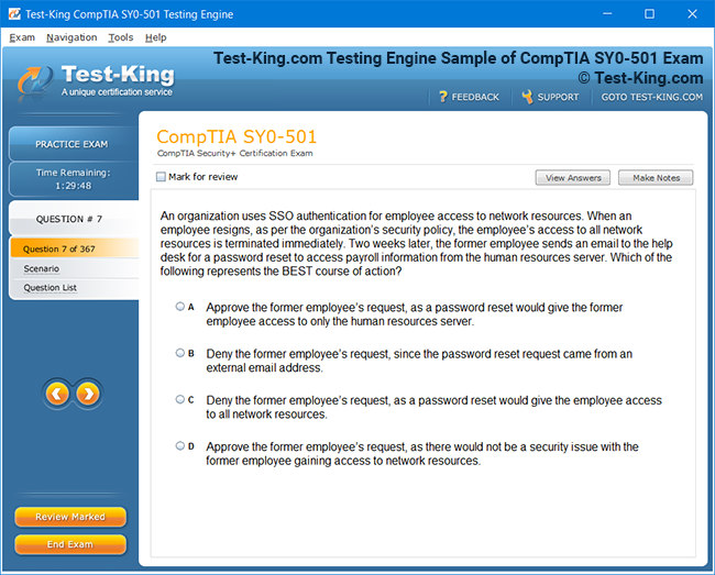
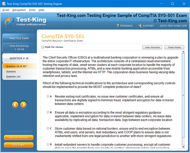
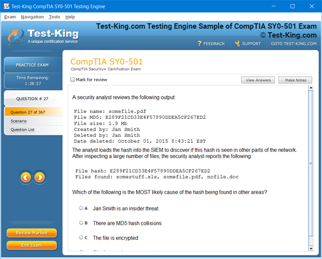
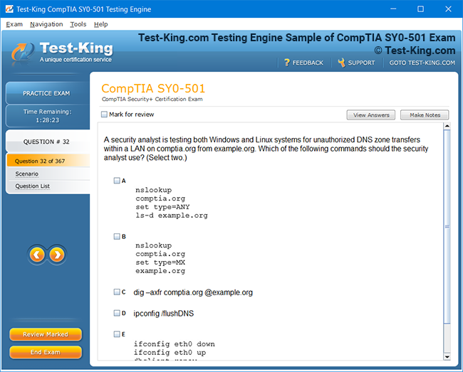
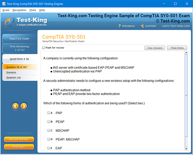
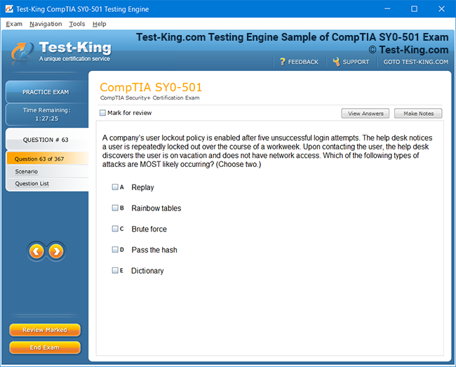
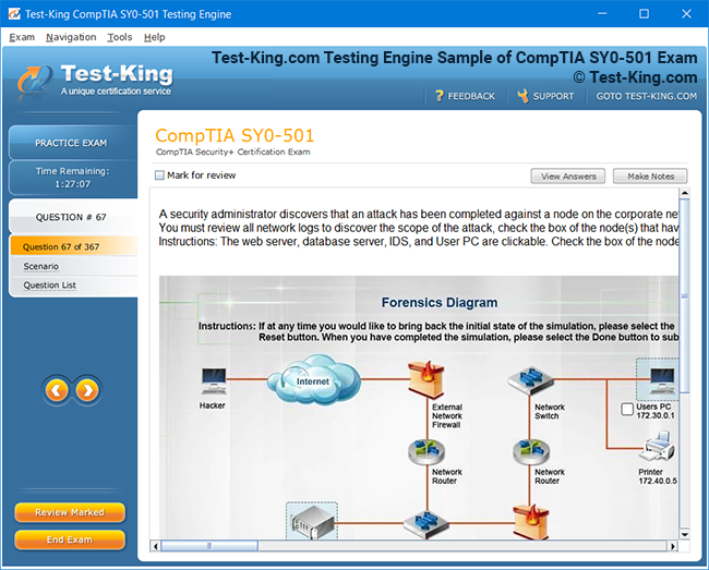
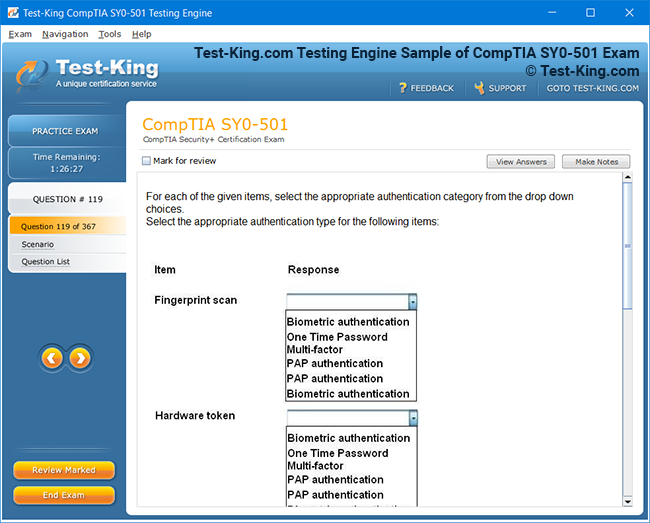
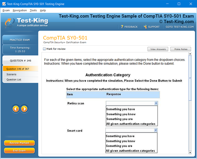
Product Screenshots

Frequently Asked Questions
How can I get the products after purchase?
All products are available for download immediately from your Member's Area. Once you have made the payment, you will be transferred to Member's Area where you can login and download the products you have purchased to your computer.
How long can I use my product? Will it be valid forever?
Test-King products have a validity of 90 days from the date of purchase. This means that any updates to the products, including but not limited to new questions, or updates and changes by our editing team, will be automatically downloaded on to computer to make sure that you get latest exam prep materials during those 90 days.
Can I renew my product if when it's expired?
Yes, when the 90 days of your product validity are over, you have the option of renewing your expired products with a 30% discount. This can be done in your Member's Area.
Please note that you will not be able to use the product after it has expired if you don't renew it.
How often are the questions updated?
We always try to provide the latest pool of questions, Updates in the questions depend on the changes in actual pool of questions by different vendors. As soon as we know about the change in the exam question pool we try our best to update the products as fast as possible.
How many computers I can download Test-King software on?
You can download the Test-King products on the maximum number of 2 (two) computers or devices. If you need to use the software on more than two machines, you can purchase this option separately. Please email support@test-king.com if you need to use more than 5 (five) computers.
What is a PDF Version?
PDF Version is a pdf document of Questions & Answers product. The document file has standart .pdf format, which can be easily read by any pdf reader application like Adobe Acrobat Reader, Foxit Reader, OpenOffice, Google Docs and many others.
Can I purchase PDF Version without the Testing Engine?
PDF Version cannot be purchased separately. It is only available as an add-on to main Question & Answer Testing Engine product.
What operating systems are supported by your Testing Engine software?
Our testing engine is supported by Windows. Andriod and IOS software is currently under development.
EADA105 Exam Breakdown: Key Domains and Skill Areas Explained
The ArcGIS Desktop Associate 10.5 certification, designated as EADA105, represents one of the most reputable milestones in the geospatial technology landscape. Developed by Esri, this exam is a hallmark of competence in using ArcGIS Desktop applications, specifically ArcMap, ArcCatalog, and ArcGIS tools essential for data visualization, spatial analysis, and cartographic representation. The EADA105 examination assesses an individual’s capability to apply geospatial principles in professional environments, ensuring that the certified individual possesses both theoretical insight and technical proficiency.
Understanding the Essence of the ArcGIS Desktop Associate 10.5 Certification
At its core, the EADA105 evaluation measures practical mastery across essential areas of GIS implementation, ranging from data organization and editing to map creation, geoprocessing, and spatial data management. This certification sits at an intermediate level within Esri’s professional pathway, bridging foundational knowledge with more specialized GIS roles such as Enterprise Administration and ArcGIS Pro expertise. The exam does not simply gauge rote knowledge of software functions; it assesses one’s ability to interpret spatial problems and execute effective workflows using Esri’s tools and environments.
To understand the EADA105 exam, one must first recognize the inherent synergy between spatial thinking, data precision, and technological versatility. The certification validates an individual’s capacity to integrate datasets from various sources, perform analytical tasks, automate workflows, and present geographic information in a coherent and visually meaningful way. Professionals who hold this credential often work in fields where geography intersects with decision-making—urban planning, environmental conservation, public safety, natural resource management, and infrastructure development.
Domains of Knowledge in the EADA105 Exam
Esri structures the EADA105 exam around distinct domains that together represent the spectrum of GIS operations within ArcGIS Desktop 10.5. Each domain contributes a significant percentage to the total exam composition, requiring examinees to maintain a balanced understanding rather than narrow expertise. The most prominent domains include data management, editing, visualization, map creation, spatial analysis, and sharing of geographic information.
The domain of data management focuses on organizing and maintaining the integrity of geographic data. Candidates are expected to demonstrate proficiency in working with shapefiles, geodatabases, rasters, and coordinate systems. Understanding the structure and behavior of geodatabases is crucial since this is where much of Esri’s data modeling and versioning capabilities are anchored. The ability to configure domains, subtypes, and relationship classes is part of this realm, as is the understanding of how to manage projection transformations and metadata documentation.
Editing and data compilation is another vital domain. It measures one’s capability to create, update, and correct geographic features. The candidate must be able to digitize vector data, handle topology rules, and perform attribute editing while maintaining logical consistency. Tools such as snapping, tracing, and topology validation play an essential role here, allowing users to preserve the geometric and attribute integrity of datasets.
Visualization and map creation form the aesthetic and communicative aspects of GIS practice. This domain evaluates the candidate’s knowledge of symbology, labeling, layout design, and the principles of effective map communication. The ability to select appropriate color schemes, manage annotation, and design layouts that convey spatial patterns clearly is as important as technical tool usage. Map production is not merely an artistic exercise; it is a process of transforming spatial data into insights, thereby reinforcing the analytical narrative behind the information.
Spatial analysis and geoprocessing represent the analytical heart of the ArcGIS Desktop environment. This domain expects candidates to apply spatial tools for overlay, buffering, proximity analysis, raster processing, and spatial statistics. Understanding how to use ModelBuilder or Python scripts to automate workflows also falls under this category, as automation ensures efficiency in repetitive analytical processes. The capacity to discern which analytical method is most suitable for a given spatial problem is a defining trait of a competent GIS analyst.
The final domain, sharing and collaboration, encompasses the ability to distribute GIS products through maps, layers, and services. It includes exporting maps, publishing data to ArcGIS Online or ArcGIS Server, and preparing files for interoperability. Candidates are evaluated on their understanding of coordinate system alignment, data packaging, and publishing workflows that maintain performance and accuracy across multiple platforms.
Exam Format and Conceptual Depth
While the EADA105 certification is delivered through a computer-based assessment, the essence of the test extends beyond multiple-choice questions. It demands applied reasoning and the ability to interpret real-world scenarios through the lens of GIS functionality. The typical duration is approximately two hours, during which the candidate encounters around eighty to ninety questions. Each question reflects a combination of technical skill, conceptual clarity, and situational awareness.
The question design may reference specific toolsets within ArcMap, such as the Spatial Analyst or Network Analyst extensions, or may describe workflows that require logical sequencing of tasks. Rather than direct recall, the exam favors comprehension—knowing why and when to use a particular function. Thus, an individual preparing for the EADA105 assessment must not only be conversant with the graphical user interface but also understand the conceptual foundation that governs spatial operations.
The exam draws upon real-world GIS challenges. For example, a question may describe a scenario in which a conservationist needs to determine habitat suitability for a particular species using multiple layers of environmental data. The candidate would need to mentally process the sequence of geoprocessing steps—reclassification, overlay, and raster calculation—that yield the desired output. Through such situational design, Esri ensures that the certification validates professional readiness rather than superficial software familiarity.
Essential Skills Evaluated by the EADA105 Exam
A closer examination of the skills assessed reveals the breadth of expertise required to excel. One essential area is spatial data creation and editing. The examinee must be adept at digitizing new features, creating attribute domains, and validating topology. Understanding snapping environments, managing coordinate systems, and using editing templates efficiently are all integral aspects of this skill set.
Another core competency is geoprocessing and spatial analysis. Candidates should know how to execute buffer, clip, intersect, and union operations and interpret their outcomes accurately. They must understand raster-based operations such as hillshade generation, raster reclassification, and map algebra. The capacity to interpret the meaning of a spatial join or a dissolve operation goes hand in hand with the ability to construct models in ModelBuilder that automate analytical processes.
Map production and layout design form another critical skill domain. Examinees are expected to manage layout elements like legends, scale bars, and north arrows while ensuring the final map adheres to cartographic standards. Understanding the difference between data frame properties and layer properties can determine whether a map correctly aligns its coordinate reference system or produces alignment errors. Layout export formats such as PDF, JPEG, or EPS also carry practical implications for sharing and presentation.
Data management is often underestimated but remains the backbone of efficient GIS operation. The exam expects an individual to comprehend geodatabase architecture, including feature datasets, subtypes, and domains. They must know how to import data from various sources such as CAD files, GPS data, and remote sensing imagery. Handling coordinate transformations accurately ensures spatial alignment, while understanding versioning concepts supports multi-user editing in enterprise environments.
Furthermore, knowledge of ArcGIS Desktop extensions enhances the candidate’s ability to apply specialized analyses. Extensions like 3D Analyst, Spatial Analyst, and Network Analyst expand the analytical horizon, offering advanced tools for surface modeling, cost-distance analysis, and route optimization. Candidates who comprehend how to enable and use these extensions within ArcMap are better positioned to address complex spatial problems with methodological precision.
The Role of Conceptual Understanding in Exam Performance
While technical fluency is indispensable, conceptual comprehension distinguishes an average GIS operator from a proficient analyst. Esri’s EADA105 exam integrates theoretical aspects such as coordinate reference systems, data models, and spatial relationships into practical questioning. For instance, understanding how geographic coordinate systems differ from projected coordinate systems is fundamental to maintaining spatial accuracy across datasets. Recognizing the difference between vector and raster data models determines how analytical tools are applied to each data type.
Topological integrity and spatial relationships form another layer of conceptual mastery. Concepts like adjacency, connectivity, and containment are not merely theoretical; they govern how datasets interact during overlay and network analysis. The exam may require candidates to interpret errors that arise from invalid topology or to suggest methods to correct spatial mismatches through editing tools. Such questions test the candidate’s depth of reasoning beyond tool usage.
Metadata management, while often overlooked, plays a crucial role in GIS data documentation. Candidates must understand how to create, edit, and maintain metadata to ensure that datasets carry descriptive, accurate, and reproducible information. Proper metadata supports data lineage, which in turn influences decision-making reliability in professional environments. The ability to evaluate data quality through metadata inspection is an implicit requirement for a competent GIS associate.
Additionally, Esri emphasizes the understanding of spatial data interoperability. As GIS increasingly integrates with web services, remote sensing, and enterprise systems, the capacity to exchange data across platforms becomes vital. Candidates must recognize file formats such as shapefile, geodatabase, KML, and GeoJSON, as well as comprehend the processes involved in converting and projecting them. This ensures that GIS outputs remain usable and accurate regardless of the software ecosystem in which they are deployed.
The Analytical Mindset Behind Exam Success
Mastery of the EADA105 exam requires more than memorizing tools and functions; it demands a cognitive approach that combines logical reasoning with spatial intuition. A candidate must approach problems like a geospatial detective, decoding patterns, anomalies, and correlations within the data. Analytical thinking allows one to move from raw spatial inputs to meaningful geographic insights. The exam’s design reflects this philosophy by embedding analytical reasoning within the context of applied geoprocessing.
Understanding data relationships is a recurring theme throughout the test. When performing joins or relates between tables, the examinee must evaluate the nature of data cardinality—whether it is one-to-one, one-to-many, or many-to-one—and predict how this will affect the resulting attribute table. Similarly, when applying spatial joins, comprehension of feature geometry—points, lines, and polygons—determines the accuracy of attribute transfer and spatial correlation.
Geoprocessing automation is another critical aspect that showcases analytical maturity. ModelBuilder and scripting enable analysts to design workflows that replicate consistent results across datasets. While the exam does not require programming expertise, familiarity with the logic of automation and the structure of models enhances efficiency and conceptual clarity. By thinking in terms of process flow rather than individual tools, candidates demonstrate the capacity to structure analyses systematically.
Visualization also embodies analytical intelligence. An effective map is not a decorative output but an interpretive product that translates complex data into spatial meaning. The candidate must select symbology that emphasizes relationships, contrasts, and hierarchies. Understanding visual variables such as hue, saturation, and size determines how effectively a map communicates its message. Through this lens, the EADA105 certification values the harmony of aesthetic sensibility and analytical precision.
Finally, communication of results remains an essential part of the analytical mindset. GIS professionals must translate technical outcomes into language and visuals comprehensible to non-specialist audiences. The exam, therefore, measures not only technical proficiency but also the candidate’s ability to present spatial findings in ways that support decision-making and strategic planning. Whether through map layouts, charts, or narrative summaries, the goal is always to make geography intelligible and actionable.
Exploring the Functional Depth of ArcGIS Desktop Workflows and Analytical Proficiency
Understanding the EADA105 certification involves more than memorizing functions or recalling menu paths. It requires a fluent command of ArcGIS Desktop 10.5 as an interconnected environment where spatial logic, database management, visualization, and analytical interpretation merge into one cohesive framework. The exam emphasizes the fluid relationship between conceptual understanding and operational dexterity, ensuring that certified individuals can not only manipulate tools but also reason through spatial challenges with precision and creativity.
At the foundational level, the candidate must perceive ArcGIS Desktop not merely as software but as a spatial intelligence ecosystem. The environment encompasses ArcMap, ArcCatalog, ArcToolbox, and supporting extensions that enable comprehensive geospatial processing. The candidate’s ability to integrate these modules harmoniously determines their overall proficiency. For example, the process of analyzing land-use change involves transitioning from ArcCatalog for data preparation to ArcMap for visualization and ArcToolbox for geoprocessing, all while maintaining data integrity and alignment.
A professional undertaking this certification must exhibit an understanding of how data structures interact within this environment. A shapefile may represent a simple yet static vector format, while a file geodatabase supports more advanced capabilities such as topology enforcement, domains, and subtypes. Recognizing when to employ each structure demonstrates analytical discernment. The EADA105 evaluation measures such discernment through situational questions that describe workflows, prompting the examinee to identify the most efficient and accurate methods to achieve specific outcomes.
ArcGIS Desktop 10.5 introduced enhancements to performance and data management that remain pivotal in the EADA105 examination. The integration of geoprocessing models, automation tools, and metadata editing within the desktop suite expanded the operational capacity of GIS professionals. The test assesses one’s ability to leverage these features strategically, rather than use them in isolation. For instance, creating a model that automates a sequence of buffer and overlay analyses demonstrates mastery of geoprocessing logic and data organization principles simultaneously.
The candidate’s understanding of coordinate systems and projection transformations remains an indispensable competency. Every dataset carries a spatial reference that determines how its features align on the earth’s surface. The EADA105 exam evaluates whether the examinee can diagnose and correct spatial misalignments caused by projection discrepancies. This involves recognizing coordinate system properties, reprojecting layers, and maintaining consistency across multiple datasets. Mastery of this aspect prevents analytical errors and ensures that spatial analysis produces reliable and meaningful results.
In addition to spatial alignment, topology integrity forms a recurring theme in the certification’s objectives. Candidates must grasp the conceptual underpinnings of topological rules—no overlaps, no gaps, connectivity between lines, and containment relationships between polygons. During editing operations, maintaining topology ensures that features behave according to logical spatial relationships. A road network must connect seamlessly, a land parcel must not overlap its neighbor, and a river line must remain within its designated channel boundary. The exam may present such scenarios to test the candidate’s ability to identify and resolve topological inconsistencies efficiently.
Map design and visualization extend beyond simple representation of data. The candidate is expected to apply cartographic principles that enhance communication and interpretation. This involves symbology selection based on data type, classification methods that reflect value distribution, and labeling strategies that preserve readability. A well-designed map communicates spatial relationships with clarity, allowing users to interpret geographic phenomena intuitively. The EADA105 exam measures whether the candidate can make decisions that balance accuracy, aesthetics, and communicative purpose within ArcMap’s layout environment.
Spatial analysis forms the analytical nucleus of the exam. Candidates must exhibit the ability to derive new insights from existing data using geoprocessing tools. For example, buffer analysis determines zones of influence around features, overlay operations reveal intersecting attributes, and spatial joins combine information from multiple datasets based on geographic relationships. Each operation requires not only tool familiarity but also interpretive understanding—what the results signify and how they contribute to solving a geographic problem. The exam questions often describe real-world cases where such reasoning must be applied, ensuring that candidates can translate analytical operations into decision-making contexts.
Raster analysis introduces another dimension of complexity, as it deals with continuous data such as elevation, temperature, or vegetation density. ArcGIS Desktop’s Spatial Analyst extension enables operations like reclassification, slope calculation, and surface modeling. The EADA105 assessment includes tasks that require comprehension of raster properties—cell size, resolution, and value range—and their influence on analytical outcomes. Understanding the difference between discrete and continuous raster data is vital, as is the ability to combine multiple raster layers through map algebra to produce derived information.
Another essential component of the exam is data conversion and integration. GIS professionals frequently encounter data in multiple formats, including CAD drawings, text files, imagery, and tabular data. The candidate must understand how to import, convert, and manage these sources within ArcGIS Desktop without losing spatial accuracy or attribute integrity. This process involves not only technical execution but also conceptual insight into data models and coordinate frameworks. The capacity to unify heterogeneous data sources into a coherent spatial database underscores the practical value of the certification.
The EADA105 examination also assesses knowledge of attribute management and relational data principles. Candidates must know how to design and manipulate attribute tables, perform field calculations, and execute joins and relates. Understanding data cardinality and table relationships ensures accurate data association during analysis. When joining tables, one must ensure that the relationship type—one-to-one or many-to-one—is appropriate for the intended analysis. Failing to maintain relational integrity can lead to analytical distortions, an issue that competent GIS practitioners must anticipate and prevent.
Metadata comprehension remains a subtle but vital part of the evaluation. Metadata functions as the descriptive framework that documents data origin, purpose, accuracy, and lineage. Within ArcCatalog, candidates must understand how to view, edit, and maintain metadata according to standardized formats. Proper metadata management ensures that datasets are reusable and interpretable by other GIS professionals, fostering transparency and continuity in spatial projects. The EADA105 exam may include tasks or scenarios that test whether the examinee can interpret metadata to determine data quality and appropriateness for analysis.
Geoprocessing models and automation through ModelBuilder occupy an important position within the exam’s scope. These tools enable analysts to construct procedural workflows that execute multiple tasks sequentially. Rather than performing repetitive operations manually, a well-designed model encapsulates logic and efficiency. Candidates should be able to conceptualize a workflow, identify its inputs and outputs, and use parameters that allow flexibility in future use. While programming is not a direct requirement, understanding model logic reflects higher-order reasoning skills that align with Esri’s expectations for certified associates.
Another skill evaluated is data sharing and interoperability. The capacity to disseminate GIS outputs effectively ensures that analytical results reach decision-makers and collaborators in accessible formats. Candidates should understand how to export map layouts, package data for sharing, and publish map services to ArcGIS Online or ArcGIS Server environments. Interoperability requires comprehension of various file formats such as shapefiles, geodatabases, and KML, along with their respective advantages and limitations. The exam assesses whether the examinee can choose suitable methods for distribution while preserving accuracy and performance.
ArcGIS Desktop 10.5 includes numerous extensions that enhance specialized workflows, and familiarity with them contributes to higher competence. For instance, the Network Analyst extension supports route optimization, service area determination, and network-based allocation analysis. Similarly, 3D Analyst facilitates surface visualization, perspective rendering, and elevation modeling. While the EADA105 exam may not focus heavily on these extensions, understanding their purpose and fundamental tools provides contextual knowledge that strengthens overall analytical proficiency.
An often-overlooked yet vital skill is the management of data precision and scale. In spatial analysis, the resolution of input data significantly influences the reliability of outputs. A dataset captured at a coarse scale cannot provide the same level of detail as one obtained from high-resolution sources. Candidates must therefore demonstrate awareness of data scale, projection distortions, and generalization effects. Such understanding ensures that conclusions drawn from spatial analysis remain valid within the context of data quality and granularity.
Error detection and quality assurance underpin the integrity of any GIS project. The EADA105 exam emphasizes the importance of identifying data anomalies, validating topology, and verifying attribute consistency. Candidates should be able to diagnose spatial errors such as slivers, gaps, and misaligned features, as well as attribute errors like null values or mismatched codes. Correcting these errors demands not only tool knowledge but also critical reasoning about spatial accuracy and dataset reliability.
The concept of spatial data storage and retrieval within geodatabases is another central area of focus. Candidates must comprehend how Esri’s geodatabase model supports multi-user editing, versioning, and data integrity. Understanding how to manage relationship classes, subtypes, and domains ensures consistency across large datasets. The EADA105 exam often tests this knowledge through scenarios involving complex data models where relational integrity must be maintained across multiple feature classes.
Beyond technical execution, the certification also values strategic problem-solving. GIS professionals must be capable of deconstructing a geographic challenge into analytical components, determining appropriate tools, and interpreting results effectively. This cognitive process represents the bridge between theoretical knowledge and applied intelligence. For example, when tasked with determining optimal locations for new facilities, an analyst must integrate multiple factors—accessibility, population density, environmental constraints—into a weighted overlay analysis. The exam gauges whether the candidate can conceptualize and rationalize such workflows.
Cartographic communication remains a fundamental theme, linking analysis to comprehension. A well-crafted map conveys not only spatial information but also analytical intention. The EADA105 exam recognizes this by assessing understanding of symbology conventions, color harmony, visual hierarchy, and data classification. Whether producing thematic maps, choropleth representations, or density visualizations, candidates must demonstrate sensitivity to how visual choices influence perception. Effective cartography synthesizes aesthetics and science into a single communicative artifact.
In professional GIS practice, documentation and project management hold equal importance to analysis itself. Candidates are expected to know how to organize project files, manage map documents, and maintain data paths. Broken links, missing layers, or inconsistent coordinate references can undermine entire analyses. The exam evaluates whether the examinee understands how to preserve data integrity through disciplined file management and logical project organization.
The EADA105 assessment also introduces scenarios involving georeferencing and data alignment. This process entails linking spatial data to a coordinate system by matching features to known control points. Understanding transformation methods—affine, similarity, polynomial—and their implications for spatial accuracy ensures that georeferenced datasets maintain positional reliability. Candidates must be able to identify when georeferencing is necessary and execute the process with precision to ensure analytical validity.
Furthermore, spatial statistics plays an understated yet significant role. ArcGIS Desktop provides tools for evaluating spatial patterns, identifying clusters, and measuring spatial autocorrelation. Candidates who comprehend these concepts gain an analytical advantage, as they can interpret geographic trends quantitatively. The exam may assess knowledge of basic statistical tools such as hot spot analysis, mean center, or standard distance, requiring both conceptual understanding and interpretive ability.
An additional domain of interest lies in data conversion between vector and raster formats. Each format serves unique analytical purposes, and the ability to transition between them broadens analytical capacity. Converting a polygon feature into a raster surface or vice versa involves considerations of resolution, attribute preservation, and analysis objectives. Understanding these nuances reflects mature GIS judgment and supports accurate analytical design.
ArcGIS Desktop 10.5’s interface flexibility allows customization through toolbars, menus, and extensions. While not the core focus of the EADA105 exam, understanding customization options demonstrates an awareness of workflow efficiency. Candidates familiar with creating custom toolsets or managing user preferences can navigate analytical tasks with greater ease and precision.
Finally, spatial data sharing through collaborative networks has become increasingly vital. With the advent of cloud-based platforms, GIS professionals must understand how to transition desktop analyses into web-accessible formats. The EADA105 certification acknowledges this evolution by testing familiarity with publishing workflows that connect ArcMap outputs to ArcGIS Online, ensuring data accessibility and interoperability in distributed environments.
Through its comprehensive structure, the EADA105 certification encapsulates the multidimensional nature of GIS expertise. It intertwines data literacy, analytical thinking, cartographic acumen, and technological fluency into a single evaluative framework. Those who pursue this credential do more than master a collection of tools—they cultivate a mindset that perceives spatial relationships as pathways to knowledge, planning, and innovation.
Advanced Spatial Intelligence and Professional Mastery within ArcGIS Desktop Environments
The Esri ArcGIS Desktop Associate 10.5 certification, also known as the EADA105 examination, represents more than a mere credential of technical expertise; it is an intellectual validation of one’s ability to interpret, manage, and operationalize spatial data with precision and foresight. This qualification examines a candidate’s capacity to navigate complex analytical landscapes, integrate data across multifarious domains, and produce cartographic outputs that reflect both accuracy and clarity. Understanding the advanced dimensions of this certification requires delving into how ArcGIS Desktop serves as an evolving spatial architecture that merges geospatial logic with real-world functionality.
Within the ArcGIS Desktop ecosystem, analytical proficiency is a synthesis of conceptual cognition and applied practice. The EADA105 exam gauges whether candidates can perceive data not as static entities but as dynamic layers of geographic intelligence. Spatial data, in its various incarnations—vector, raster, tabular, and imagery—forms the substratum of geographic analysis. The candidate’s task is to discern relationships among these data types, establish coherent analytical pathways, and extract insights that influence tangible decision-making. This demands not only software familiarity but also an almost philosophical comprehension of spatial reasoning.
The notion of data structure plays a pivotal role in the candidate’s success. The Esri file geodatabase, for example, functions as a repository that encapsulates features, attributes, relationships, and rules that maintain data consistency. Unlike simple shapefiles, geodatabases can enforce topological integrity, support subtypes, and store annotation. The exam’s subtle complexity lies in determining when and why to utilize a specific data storage model. A candidate must intuitively understand that the geodatabase fosters not only organization but also analytical scalability, enabling complex operations without data degradation.
Equally significant is the command of coordinate systems and projections. Each spatial dataset aligns with a geographic coordinate system that defines its location on the earth’s surface. Misalignment between coordinate systems can result in analytical distortions, which in professional environments can compromise critical decisions. Candidates must be adept at identifying the coordinate properties of datasets, performing projection transformations, and understanding the mathematical implications of those transformations. The EADA105 exam probes this competence through scenarios that require diagnosing spatial discrepancies and applying the appropriate geoprocessing tools to rectify them.
Spatial data editing, another key competency, involves far more than digitizing features. It represents a meticulous process of ensuring geometrical accuracy and logical consistency within a dataset. Through ArcMap’s editing tools, candidates are expected to demonstrate fluency in creating new features, adjusting existing geometries, and maintaining attribute correctness. This extends to understanding snapping environments, topology rules, and feature templates. Editing also encompasses attribute refinement, such as recalculating fields, assigning default values, and validating data entries to maintain conformity with domain constraints.
In the context of topology, the EADA105 exam challenges candidates to enforce spatial relationships that reflect real-world logic. Connectivity, adjacency, containment, and coincidence are not abstract notions but practical constructs that determine how features interact. For instance, a river line should intersect the polygon representing its basin, and road segments should meet seamlessly at junctions. The ability to identify and correct topological errors underscores one’s spatial awareness and data stewardship.
Geoprocessing stands at the very center of the exam’s analytical assessment. This domain encompasses the use of ArcToolbox operations to manipulate and analyze spatial data. Candidates must demonstrate mastery of tools that perform overlay, proximity, extraction, and conversion operations. Each tool represents a building block in constructing spatial logic. Buffer tools delineate areas of influence, intersect tools merge attributes based on spatial coincidence, and dissolve tools generalize features by shared attributes. The subtlety lies in knowing which sequence of operations produces a valid and interpretable outcome.
Raster analysis introduces another plane of complexity. Unlike vector data, which is discrete and feature-based, raster data represents continuous phenomena. Candidates are required to interpret and manipulate raster surfaces through operations such as reclassification, resampling, slope calculation, and hillshade generation. Each raster operation relies on understanding cell resolution, data type, and value range. The EADA105 examination frequently tests this knowledge through analytical case studies, such as deriving land suitability models or evaluating environmental risk zones.
Another fundamental competency involves data integration and conversion. The ability to merge disparate data sources—ranging from CAD drawings to GPS points and remote sensing imagery—is vital in contemporary GIS workflows. Candidates must understand how to import, project, and convert these datasets without compromising spatial fidelity. ArcGIS Desktop 10.5 supports multiple data formats, and understanding their interoperability allows analysts to unify data into coherent analytical environments. The exam assesses whether candidates can navigate this diversity fluidly, transforming fragmented sources into synchronized spatial intelligence.
Map production and visualization are equally significant components of the EADA105 examination. Cartography within ArcGIS Desktop transcends mere aesthetics; it embodies analytical storytelling. A well-designed map reflects discernment in symbology, classification, and layout composition. Candidates are expected to select symbology that conveys data meaning accurately, choose classification schemes that represent value distribution, and design layouts that maintain readability and focus. Labeling strategy, legend placement, and scale selection all influence how information is perceived. In professional GIS applications, maps are communicative instruments that translate spatial complexity into human understanding.
Beyond visual design, map elements such as north arrows, scale bars, and coordinate grids play functional roles in ensuring spatial credibility. A cartographer must maintain proportional relationships and spatial references that allow viewers to interpret geographic extent accurately. The exam may include scenarios where candidates must diagnose design errors or recommend improvements that enhance interpretive clarity. The ultimate aim is to ensure that maps do not merely depict data but narrate spatial truth.
Metadata comprehension forms the backbone of data documentation. It provides contextual insight into the creation, accuracy, lineage, and intended use of spatial datasets. Within ArcCatalog, candidates must be familiar with metadata editing interfaces, templates, and standards. Metadata ensures that data remains interpretable and reliable even as it transitions between users or projects. The EADA105 exam may challenge candidates to interpret metadata entries to evaluate dataset suitability for specific analyses. This skill is indispensable for maintaining data transparency and reproducibility in collaborative environments.
The concept of data quality assurance extends this principle into active management. Accuracy, completeness, consistency, and currency are critical dimensions of spatial data quality. Candidates must demonstrate the ability to evaluate datasets for these characteristics, often through visual inspection, topology validation, and attribute verification. The examination reflects real-world expectations, where GIS professionals must ensure that analytical outputs are not undermined by faulty or outdated information.
Spatial statistics adds yet another dimension to the analytical repertoire. ArcGIS Desktop provides statistical tools to quantify spatial patterns, measure clustering tendencies, and identify spatial anomalies. Candidates who understand these concepts gain an advantage in interpreting data beyond visual inspection. Tools such as mean center, standard distance, and hot spot analysis quantify spatial distribution and relationships. The exam’s inclusion of such topics underscores Esri’s emphasis on analytical rigor and the fusion of spatial and statistical reasoning.
Georeferencing remains a vital operation within ArcGIS workflows, ensuring that non-spatial datasets acquire geographic meaning. Candidates must understand how to align scanned maps, CAD drawings, or imagery to a coordinate system by assigning control points that correspond to known geographic locations. Mastery of transformation methods such as affine, polynomial, or spline ensures spatial precision. The EADA105 evaluation may present georeferencing challenges that require the candidate to select appropriate methods and assess positional accuracy through residual error analysis.
Equally important is the concept of data sharing and dissemination. GIS is not an isolated discipline; it thrives on collaboration and data exchange. Candidates must understand how to export map layouts, package data for sharing, and publish map services to ArcGIS Online or ArcGIS Server. This involves comprehension of performance optimization, data compression, and coordinate system compatibility. The EADA105 exam emphasizes the ability to ensure that shared datasets retain both usability and spatial integrity across different platforms.
An advanced area of examination involves automation and process optimization through ModelBuilder. This graphical tool enables users to construct workflows that execute sequences of geoprocessing operations automatically. Candidates are expected to understand how to build, parameterize, and validate models that replicate analytical processes. Automation is not simply a convenience; it represents methodological discipline. The capacity to design reusable workflows reflects professional maturity and systematic thinking—qualities that Esri values in certified associates.
Data management within enterprise geodatabases introduces an understanding of versioning, replication, and multi-user editing. Candidates must comprehend how Esri’s geodatabase framework supports collaborative data editing without conflicts or redundancy. Understanding how to reconcile and post versions ensures synchronization and continuity in team environments. The exam evaluates whether the examinee can conceptualize and manage such workflows efficiently, a competence essential for organizational GIS operations.
Error detection and correction represent another crucial skill set. GIS data, like all information, is susceptible to human and systemic errors. Candidates must demonstrate diagnostic abilities to identify inconsistencies such as invalid geometries, attribute mismatches, or projection errors. The EADA105 exam may describe data anomalies and expect candidates to select appropriate tools and reasoning steps for correction. This mirrors real-world GIS responsibilities, where maintaining data fidelity directly impacts analytical outcomes.
ArcGIS Desktop’s extensibility is another facet of proficiency that reflects adaptability. Understanding how to activate and use extensions such as Spatial Analyst, 3D Analyst, or Network Analyst expands analytical potential. The Network Analyst extension, for instance, facilitates route optimization and service area analysis, while 3D Analyst allows for terrain modeling and visualization of elevation data. The exam may reference these capabilities indirectly, testing whether candidates recognize the contexts in which such extensions become indispensable.
In addition to technical mastery, the EADA105 examination probes professional reasoning—how candidates conceptualize spatial problems and construct analytical strategies. For instance, determining optimal locations for new infrastructure requires integrating demographic, environmental, and accessibility factors into a cohesive analysis. Candidates must understand how to apply weighted overlay techniques and multi-criteria evaluation frameworks. This analytical reasoning reflects Esri’s expectation that certified professionals can translate spatial data into actionable knowledge.
Project management principles also influence the way GIS operations are executed. Candidates must know how to organize project files, manage map documents, and ensure that data paths remain valid across different systems. Proper project structuring prevents data loss, broken links, and workflow inefficiencies. The exam’s emphasis on such practicalities reinforces the importance of meticulous organization in maintaining project integrity.
Interoperability represents the modern dimension of GIS proficiency. With the proliferation of web-based GIS platforms, professionals must understand how desktop analyses integrate with online environments. Candidates are expected to be familiar with processes that convert local projects into web services accessible through ArcGIS Online. This entails knowledge of coordinate compatibility, service publishing, and symbology translation across platforms. The EADA105 certification thus bridges traditional desktop GIS with emerging digital geographies.
Ultimately, mastery of the ArcGIS Desktop Associate 10.5 domain is an intellectual and professional endeavor. The EADA105 exam demands a synthesis of spatial reasoning, analytical precision, and cartographic articulation. Candidates who excel embody not only technical fluency but also the cognitive versatility to perceive the world through a spatial lens. They become custodians of geographic knowledge, transforming raw data into meaningful insight that shapes understanding, policy, and innovation across diverse industries.
Integrating Spatial Logic, Analytical Precision, and Professional Competence in Esri ArcGIS Desktop
The ArcGIS Desktop Associate 10.5 certification known as EADA105 exemplifies a confluence of geospatial cognition, analytical aptitude, and professional discipline. Within the environment of Esri’s ArcGIS Desktop, success in this examination is not dictated merely by tool familiarity but by the ability to interlace conceptual awareness with empirical reasoning. The test measures whether an individual can harmonize geographic data, interpret patterns within spatial contexts, and communicate analytical results through coherent and intelligible cartography. As spatial data evolves into a foundational element of decision-making across governments, academia, and private enterprise, the mastery of ArcGIS Desktop 10.5 becomes an indispensable professional asset.
ArcGIS Desktop is a multifaceted suite consisting primarily of ArcMap, ArcCatalog, and ArcToolbox, supported by specialized extensions that expand analytical functionality. The examination evaluates how well candidates can navigate these interrelated modules and employ them as a seamless analytical continuum. ArcMap serves as the principal workspace for map visualization, geoprocessing, and spatial editing. ArcCatalog provides the organizational and metadata framework for managing geodatabases, while ArcToolbox houses the arsenal of geoprocessing tools that enable spatial transformation. Understanding the symbiosis among these components reflects the analytical maturity expected from a certified professional.
Spatial data organization represents the substrate of the certification’s content. The candidate must internalize the hierarchical architecture of Esri’s geodatabase model, encompassing feature datasets, feature classes, and relationship classes. This structure supports complex spatial modeling, including subtypes and domains that regulate attribute behavior. The EADA105 examination measures the extent to which candidates can construct, maintain, and interpret these structures efficiently. A nuanced comprehension of geodatabase functionality allows a professional to enforce consistency, minimize redundancy, and foster analytical reproducibility across diverse GIS projects.
Within the broader framework of spatial management, coordinate systems function as the geometric spine of geographic accuracy. Every dataset is inherently tied to a spatial reference that defines its position on the Earth’s surface. Misalignment or inconsistency among coordinate systems can propagate analytical distortions that compromise integrity. Candidates must exhibit proficiency in identifying coordinate systems, performing projection transformations, and understanding datum implications. The exam often introduces scenarios requiring alignment correction, thereby assessing both theoretical and procedural knowledge of coordinate geometry.
Data editing within ArcGIS Desktop requires precision and a disciplined workflow. Candidates are expected to demonstrate mastery in digitizing features, refining geometries, and preserving attribute accuracy. Editing environments demand comprehension of snapping tolerances, topology validation, and version management. For example, when creating a cadastral dataset, even minute spatial discrepancies can lead to interpretive inaccuracies. The ability to identify and rectify such deviations is not simply technical but analytical, requiring both visual acuity and cognitive attentiveness.
The editing process extends beyond geometric adjustments to encompass attribute management. Attributes provide the semantic content that gives spatial features meaning. Through ArcMap’s attribute tables, candidates must understand field creation, data typing, and value constraints. Editing also involves the use of subtypes and coded domains that standardize data entry. These mechanisms prevent inconsistencies and maintain attribute fidelity across large datasets. The EADA105 exam evaluates a candidate’s capacity to configure and apply these constructs logically within a geodatabase.
Spatial analysis stands as the intellectual heart of the certification. It transforms raw geographic data into interpretable insight through systematic reasoning. The examination explores whether candidates can select, apply, and sequence analytical tools to resolve complex spatial questions. For example, understanding when to use overlay analysis versus proximity analysis reflects conceptual discernment. The candidate must comprehend the purpose of tools such as buffer, clip, erase, and intersect, not merely their interface location. Each operation represents a step in a deductive process that transforms spatial relationships into tangible outcomes.
Raster analysis introduces continuous data modeling into this analytical matrix. Unlike vector data, raster datasets represent phenomena such as temperature, elevation, or precipitation in a grid structure where each cell carries a value. Candidates must understand cell resolution, spatial extent, and value range. Analytical processes like reclassification, surface modeling, or map algebra require cognitive fluency in both arithmetic and spatial reasoning. The EADA105 examination includes conceptual and applied dimensions of raster analysis, testing whether candidates can interpret raster outputs and integrate them into comprehensive spatial workflows.
Data integration is another cornerstone of the certification. Professionals often encounter disparate sources of information—ranging from GPS data and remote sensing imagery to tabular records and CAD drawings. The ability to harmonize these data types within ArcGIS Desktop determines the efficiency of any subsequent analysis. Candidates must understand import mechanisms, coordinate reconciliation, and format conversion. The exam may describe scenarios in which multiple data sources must be unified into a consistent geospatial database, assessing whether the examinee can preserve accuracy while facilitating interoperability.
Map design and visualization merge analytical depth with communicative clarity. A map within ArcGIS Desktop is both a technical output and a rhetorical instrument that conveys geographic knowledge. The candidate must exercise discernment in symbology selection, classification methods, and layout composition. Effective maps rely on visual hierarchy, ensuring that essential information captures immediate attention while supporting details remain accessible but unobtrusive. Color theory, contrast, and annotation placement contribute to the map’s interpretive power. The EADA105 examination measures whether candidates can integrate these principles into aesthetically coherent and functionally precise cartographic products.
Labeling and annotation represent another subtle but vital dimension of cartography. Candidates must understand dynamic labeling rules, annotation feature classes, and text symbolization. Inaccurate or overlapping labels can distort interpretation, whereas well-structured annotation enhances comprehension. The professional task lies in balancing legibility with spatial economy, ensuring that textual elements support rather than overwhelm the visual narrative.
Metadata serves as the documentary memory of spatial datasets. It records creation processes, sources, accuracy assessments, and intended applications. Within ArcCatalog, candidates must be proficient in accessing, editing, and interpreting metadata. This competence ensures data transparency and reliability, especially when datasets are exchanged among organizations or integrated into long-term projects. The EADA105 exam’s emphasis on metadata reflects Esri’s commitment to reproducible and accountable GIS practices.
Data sharing and publication represent the externalization of GIS knowledge. Professionals must be capable of disseminating their work through appropriate channels while maintaining spatial integrity and performance. ArcGIS Desktop facilitates export to multiple formats such as shapefiles, geodatabases, and map packages, as well as web publishing through ArcGIS Online and ArcGIS Server. The candidate must know how to prepare data for sharing, including projection alignment, symbol standardization, and compression techniques. The exam evaluates whether the examinee can ensure compatibility and clarity in collaborative contexts.
Automation and workflow optimization form another critical layer of the exam’s expectations. ModelBuilder in ArcGIS Desktop enables analysts to construct visual workflows that execute a series of geoprocessing steps automatically. Candidates should demonstrate understanding of model construction, parameterization, and validation. Automation minimizes redundancy and enhances efficiency, but it also demands conceptual precision in defining dependencies and logical order. The EADA105 evaluation values candidates who can think algorithmically, structuring processes that replicate analytical reasoning.
Error detection and quality assurance anchor the reliability of GIS analysis. Spatial data errors can manifest in geometry, attributes, or coordinate references. Candidates must know how to identify invalid geometries, resolve topological inconsistencies, and validate attribute completeness. Understanding the implications of positional accuracy and logical consistency ensures that analyses remain defensible. The exam assesses not only the ability to correct errors but also to anticipate them through preventive data management practices.
ArcGIS Desktop’s extensibility through specialized modules broadens the professional’s analytical spectrum. Familiarity with tools such as Spatial Analyst, 3D Analyst, and Network Analyst demonstrates comprehensive competence. For instance, the Network Analyst extension enables modeling of transportation systems, service areas, and network-based accessibility. The Spatial Analyst extension supports advanced raster calculations, while 3D Analyst provides elevation modeling and perspective visualization. Even if not directly tested in detail, awareness of these tools reflects readiness for complex professional tasks that demand multidimensional analysis.
Project management within ArcGIS Desktop encompasses organizing files, maintaining data paths, and safeguarding integrity across collaborative environments. Candidates should understand the structure of map documents, relative path settings, and data source linking. Efficient project organization prevents data fragmentation and ensures analytical continuity. The EADA105 exam indirectly tests this understanding by presenting scenarios where project mismanagement could lead to analytical discrepancies, requiring the candidate to identify and resolve structural inefficiencies.
Spatial data conversion between vector and raster formats epitomizes the fluid adaptability expected of certified professionals. Candidates must understand the conceptual differences between these models and the consequences of conversion, such as resolution loss or attribute simplification. Recognizing when conversion enhances analytical value or introduces unnecessary complexity marks the distinction between procedural knowledge and analytical wisdom.
Spatial statistics and pattern recognition form another dimension of professional mastery. ArcGIS Desktop provides tools for detecting clusters, measuring spatial autocorrelation, and determining distributional tendencies. Understanding concepts such as mean center, standard distance, and hot spot identification allows analysts to move beyond visual impressions into quantitative validation. The exam’s inclusion of spatial statistical reasoning underscores Esri’s emphasis on holistic understanding that integrates mathematics, geography, and technology.
Georeferencing continues to play a foundational role in the practical dimension of GIS operations. Candidates must know how to align raster or vector data lacking spatial reference by assigning control points that correspond to real-world coordinates. The selection of transformation methods—affine, spline, or polynomial—depends on data characteristics and required accuracy. Understanding residual errors and root-mean-square deviations ensures that georeferenced outputs maintain positional reliability. Such operations require patience, spatial intuition, and precision—traits that distinguish a skilled GIS professional from a mere technician.
Interoperability and data exchange across systems and organizations constitute the modern frontier of GIS practice. ArcGIS Desktop 10.5 supports a wide range of formats including GeoJSON, KML, and CAD integrations. Candidates must comprehend how to maintain data integrity when exporting or importing across platforms. This includes managing coordinate transformations, encoding standards, and attribute consistency. The exam reflects this practical reality by assessing a candidate’s awareness of the global ecosystem in which GIS data circulates.
Another domain of understanding involves the management of temporal data. Geographic phenomena often change over time, and ArcGIS Desktop provides tools for tracking and visualizing temporal variation. Candidates may encounter exam scenarios requiring interpretation of time-enabled data, understanding temporal attributes, and animating changes to reveal trends. Integrating time as a variable deepens spatial comprehension and enriches analytical narratives.
Spatial modeling and predictive analysis form an emerging yet integral part of GIS competence. The EADA105 evaluation may introduce analytical reasoning involving suitability modeling, cost-distance analysis, or predictive surface generation. Candidates must know how to combine multiple spatial layers using weighted overlays and interpret the results as indicators of potential outcomes. This form of reasoning connects GIS practice to real-world planning and resource management.
An additional layer of sophistication lies in understanding symbology and classification techniques. Graduated color schemes, proportional symbols, and unique value representations each convey specific analytical meanings. Choosing appropriate classification methods—natural breaks, quantiles, equal intervals—requires comprehension of statistical distribution within the dataset. The candidate’s ability to balance accuracy with clarity in symbology directly influences the interpretive power of the map.
Network analysis remains a critical function that extends beyond simple mapping. It requires conceptualization of connectivity and impedance within transportation or utility systems. Understanding how to build network datasets, define impedance attributes, and perform route optimization represents a practical application of spatial reasoning. Although the EADA105 exam may not delve into intricate network configurations, its scenarios often touch upon fundamental routing and accessibility concepts.
A holistic grasp of the ArcGIS Desktop environment also involves awareness of its evolving integration with ArcGIS Pro and cloud-based platforms. Candidates must appreciate the transition in Esri’s technological architecture, recognizing that principles mastered within Desktop remain transferable to newer interfaces. This adaptability is intrinsic to the certification’s value, ensuring that professionals remain relevant in the face of rapid software evolution.
Ultimately, the EADA105 examination embodies a synthesis of technical fluency, conceptual understanding, and analytical dexterity. It compels candidates to think spatially, reason logically, and act methodically within the geospatial framework established by Esri. Mastery of this certification signifies more than passing an exam; it denotes the ability to transform raw geographic information into structured knowledge that guides decisions, shapes policies, and enhances our comprehension of spatial relationships within the world’s intricate tapestry.
Understanding Advanced Spatial Management and Analytical Proficiency within Esri ArcGIS Desktop Associate 10.5
The ArcGIS Desktop Associate 10.5 certification represented by EADA105 demands an equilibrium between analytical precision, spatial awareness, and professional maturity. It is designed to assess not only an individual’s command of Esri technology but also their intellectual fluency in translating geographic data into actionable intelligence. At this level, a candidate’s comprehension transcends mechanical manipulation of software tools, evolving into a holistic understanding of spatial cognition. Esri’s ArcGIS Desktop environment forms a sophisticated ecosystem where geodatabases, cartographic representations, analytical algorithms, and data governance interweave seamlessly to form the foundation of spatial science in practice.
ArcGIS Desktop encompasses a trinity of principal applications—ArcMap, ArcCatalog, and ArcToolbox—that together define the analytical workflow. ArcMap serves as the nerve center for cartographic visualization, geoprocessing, and spatial editing. ArcCatalog functions as a structured repository for data organization, cataloging, and metadata curation, while ArcToolbox operates as a repository of geoprocessing instruments essential for transformation and analysis. Mastery of these tools requires not only technical familiarity but also the ability to orchestrate them into coherent analytical strategies. The EADA105 exam measures whether candidates possess this integrative thinking and can demonstrate efficiency in navigating among these applications.
Within ArcGIS Desktop, spatial data management begins with a disciplined understanding of the geodatabase model. This architecture provides a structured hierarchy that supports robust data governance. A geodatabase consists of feature datasets, feature classes, tables, and relationship classes, each serving a specialized purpose. Feature datasets are conceptual groupings that allow shared spatial references, ensuring geometric compatibility. Feature classes embody the actual spatial entities—points, lines, or polygons—representing physical phenomena such as roads, parcels, or hydrological features. Relationship classes articulate how different datasets interconnect logically, allowing the construction of dynamic spatial relationships. The candidate must exhibit the ability to create and maintain these structures while applying subtypes and domains that standardize attribute behavior across datasets.
Spatial referencing remains a pivotal concern in all geospatial operations. A coordinate system is the language through which geographic phenomena communicate their location on the Earth’s surface. The EADA105 examination expects candidates to differentiate between geographic and projected coordinate systems, comprehend the meaning of datums, and manage transformations between spatial references. The ability to identify and rectify coordinate discrepancies ensures that data layers align correctly, a foundational step in spatial integrity. Inconsistent coordinate systems often lead to analytical distortions, and thus the candidate must recognize, diagnose, and rectify these discrepancies effectively.
Editing and data maintenance in ArcGIS Desktop require meticulous discipline. A skilled professional must understand how to create new features, modify geometries, and ensure topological precision. Editing sessions involve tools that define snapping tolerances, maintain connectivity, and validate topology rules. For example, when digitizing road networks, ensuring line connectivity without overshoots or gaps is essential for subsequent network analysis. Similarly, polygon boundaries must close accurately to maintain valid geometries. The EADA105 exam frequently assesses whether candidates can identify and correct such issues using both automated and manual techniques.
Equally essential is the attribute dimension of spatial editing. Attributes describe the non-spatial characteristics of geographic entities, transforming mere geometry into meaningful information. Within attribute tables, candidates must demonstrate understanding of field data types, constraints, and value integrity. Subtypes and coded domains play a vital role in maintaining uniformity by restricting input to valid options. This enforces data consistency, a hallmark of professional GIS practice. The EADA105 exam often includes conceptual tasks that test how candidates apply these mechanisms in real-world data management scenarios.
Geoprocessing in ArcGIS Desktop constitutes the analytical backbone of spatial problem-solving. The suite of tools available in ArcToolbox enables transformation, extraction, overlay, and analysis. The exam tests understanding of the logical order in which these tools are applied. For instance, the concept of data preparation precedes analysis, which in turn precedes visualization. Geoprocessing involves chaining operations such as buffering, intersecting, merging, dissolving, and clipping. Candidates must know not only what each tool accomplishes but also the conceptual rationale for its use in a given workflow. The sequencing of operations often determines the success or failure of an analytical endeavor.
Raster data management introduces continuous phenomena into the analytical landscape. In contrast to vector representations, raster datasets use cells to store values representing elevation, temperature, vegetation, or other continuous variables. A deep understanding of resolution, extent, and cell size relationships is critical. Analytical methods like reclassification, map algebra, and surface modeling form the basis for raster analysis. The EADA105 exam evaluates whether candidates comprehend how raster functions integrate with vector data and how to apply them for predictive modeling and environmental assessment.
Integration of heterogeneous data sources forms an essential part of professional GIS workflows. Practitioners must frequently merge data from remote sensing imagery, GPS observations, CAD drawings, and tabular information. ArcGIS Desktop provides tools for data import, coordinate transformation, and attribute joining. The candidate’s ability to consolidate these disparate formats into a unified analytical framework is crucial. The exam might depict scenarios in which datasets require harmonization, demanding the application of spatial reasoning alongside procedural precision.
Cartographic representation remains the communicative endpoint of GIS analysis. In ArcMap, the art of symbology translates analytical insight into perceptible form. Map design involves principles of visual hierarchy, contrast, balance, and thematic clarity. The candidate must understand classification methods such as quantile, natural breaks, or equal interval to represent data appropriately. Color selection, annotation, and scale management influence interpretability. A professionally designed map conveys information without ambiguity, guiding the viewer’s cognition through spatial narrative rather than overwhelming them with visual noise.
Metadata management constitutes the archival dimension of spatial information. It preserves the lineage and integrity of datasets, recording essential details such as source, accuracy, and intended use. Within ArcCatalog, candidates must demonstrate proficiency in creating, editing, and interpreting metadata entries. This not only fulfills organizational standards but also supports reproducibility and transparency. A professional GIS practitioner recognizes metadata as a critical companion to spatial data, ensuring that analytical outputs remain traceable and defensible.
ArcGIS Desktop’s ModelBuilder environment introduces the concept of automation within geospatial analysis. Through ModelBuilder, sequences of geoprocessing tasks can be assembled into repeatable workflows. Candidates must grasp the principles of model construction, parameterization, and execution. The advantage of automation lies in efficiency and consistency, reducing human error and saving time. The EADA105 exam expects candidates to interpret scenarios where a model could streamline repetitive analysis, reflecting an understanding of how automation integrates with analytical logic.
Error management and quality assurance underscore the scientific rigor of spatial analysis. Errors may arise from digitization, coordinate transformations, or attribute misentries. Candidates must understand how to detect invalid geometries, correct topological violations, and validate attribute completeness. Accuracy assessment often involves evaluating positional precision and logical consistency. Esri’s software provides mechanisms for topology validation and error reporting, and the exam expects candidates to know how to interpret and resolve these feedback indicators.
Network analysis represents a specialized dimension of GIS focused on connectivity and accessibility. Within ArcGIS Desktop, professionals create network datasets that model transportation or utility systems. These datasets include impedance attributes such as distance or travel time. Analytical tools support route optimization, service area delineation, and facility location assessment. Understanding the conceptual underpinnings of network analysis allows candidates to design efficient infrastructure planning solutions. Although not every detail of this domain appears in the EADA105 exam, familiarity with its principles reflects analytical readiness.
The role of spatial statistics continues to expand as GIS evolves from descriptive mapping to inferential analysis. ArcGIS Desktop includes tools that measure spatial patterns, identify clusters, and test hypotheses about spatial distributions. Understanding spatial autocorrelation, mean center, and standard distance enables candidates to validate observed spatial trends quantitatively. The inclusion of statistical reasoning in the exam reinforces the idea that GIS professionals must be capable of interpreting not only where phenomena occur but also why and how they exhibit spatial behavior.
Georeferencing is another indispensable operation in the professional’s repertoire. It involves aligning non-referenced images or datasets with spatially known coordinates. The process requires the identification of control points, selection of appropriate transformation methods, and evaluation of root-mean-square errors. A candidate who understands these principles ensures that legacy maps or aerial photographs integrate seamlessly into modern coordinate systems. The EADA105 exam often includes conceptual assessments that gauge whether examinees can discern appropriate georeferencing methods for specific contexts.
Data sharing and dissemination are integral to collaborative GIS practice. ArcGIS Desktop facilitates data exchange through formats such as shapefiles, geodatabases, and map packages. Preparing data for sharing involves ensuring coordinate consistency, compressing file sizes, and standardizing symbology. Web integration through ArcGIS Online and ArcGIS Server further extends dissemination potential, allowing dynamic maps and services to reach broader audiences. The exam evaluates a candidate’s understanding of how to prepare, publish, and maintain datasets in shared environments.
Temporal analysis introduces the dimension of change into spatial reasoning. Many geographic phenomena evolve over time, and ArcGIS Desktop supports temporal visualization that reveals trends and trajectories. Candidates should understand how to enable time-aware data, set temporal intervals, and animate changes. This capacity enriches analytical interpretation by allowing professionals to perceive evolution rather than static snapshots. The EADA105 exam’s conceptual orientation toward temporal understanding reflects the discipline’s growing emphasis on dynamic processes.
Data transformation and conversion processes form another critical layer of GIS operations. Converting between raster and vector models requires appreciation of both representation and accuracy. Rasterization may simplify complex vector geometries but facilitate continuous modeling, whereas vectorization translates raster grids into discrete entities suitable for precise boundary analysis. Recognizing when to perform these transformations is essential for maintaining analytical fidelity. The exam may evaluate candidates on their understanding of the conceptual implications rather than the mechanical steps of conversion.
An understanding of data interoperability distinguishes a proficient analyst from a novice operator. Modern GIS environments interact with external systems such as remote sensing platforms, CAD software, and statistical applications. ArcGIS Desktop supports formats like KML, GeoJSON, and DXF, enabling cross-platform communication. The EADA105 exam often incorporates conceptual items that assess whether candidates appreciate the complexities of maintaining data integrity across systems. The ability to ensure consistency during import or export operations exemplifies professionalism in spatial data handling.
Spatial modeling synthesizes multiple datasets into comprehensive analytical frameworks. Suitability analysis, cost distance modeling, and predictive surface generation exemplify this integrative reasoning. Candidates must know how to assign weights to input variables and interpret composite results. Such modeling reflects real-world decision-making processes in environmental planning, urban development, and resource allocation. The exam assesses whether candidates can conceptualize these analyses within Esri’s ArcGIS Desktop environment and articulate the logic underpinning them.
Map automation and scripting extend the power of GIS beyond manual operation. Although scripting is not directly examined in EADA105, conceptual awareness of automation principles indicates readiness for more advanced certifications. Understanding how repetitive tasks can be automated through model parameters or batch processing reflects strategic foresight. A certified professional is expected to optimize workflows, conserving both time and cognitive resources.
Spatial data validation ensures that analysis remains credible and replicable. Professionals implement validation routines to verify geometry, attributes, and relationships. The topology rules available in ArcGIS Desktop serve as a governance mechanism that enforces spatial logic. Violations highlight inconsistencies such as overlaps, gaps, or dangling features. By resolving these systematically, the analyst maintains the structural integrity of datasets. The exam’s inclusion of these topics signifies the importance of spatial correctness as a core professional value.
Advanced map design incorporates cartographic artistry with scientific discipline. Beyond symbolization and labeling, it encompasses the orchestration of visual narrative. Effective map composition employs balance between data density and readability. Layout elements such as legends, scale bars, and north arrows must be proportionate and contextually positioned. The EADA105 exam measures whether candidates understand the principles of clarity, contrast, and composition that govern professional cartography.
ArcGIS Desktop’s ability to integrate with external databases through OLE DB or SQL connections broadens its analytical scope. Candidates must understand how to establish and manage these connections to query and manipulate external data sources. The capacity to merge spatial and non-spatial information enhances analytical depth, allowing professionals to synthesize data across domains. This represents one of the subtle competencies expected of an associate-level certified individual.
The examination also touches on data storage optimization and system performance. Professionals must appreciate the implications of dataset size, index creation, and coordinate precision on processing efficiency. Strategies such as feature generalization, data compression, and caching contribute to system optimization. Candidates who understand these factors demonstrate readiness to manage large-scale spatial projects effectively.
As spatial analysis increasingly informs global policy and enterprise decisions, the expectations placed upon GIS professionals continue to escalate. The ArcGIS Desktop Associate 10.5 certification encapsulates this professional paradigm by demanding both depth and breadth of understanding. The candidate who aspires to excel in the EADA105 examination must not only memorize workflows but internalize the underlying logic of spatial reasoning. Through mastery of data management, geoprocessing, visualization, and automation, the certified individual stands equipped to transform raw spatial data into coherent, impactful knowledge that influences tangible outcomes across the real world.
Mastering Advanced Analytical Workflows, Spatial Reasoning, and Professional GIS Practices
The ArcGIS Desktop Associate 10.5 certification, identified as EADA105, represents a synthesis of professional competence, analytical sophistication, and spatial intelligence. Achieving this credential demands a nuanced comprehension of the ArcGIS Desktop environment, where conceptual knowledge and operational fluency coalesce. Candidates are evaluated not merely on procedural execution but on their capacity to reason spatially, integrate diverse datasets, and produce analytical outputs that are both accurate and communicatively effective. This final portion examines the advanced aspects of spatial data management, analysis, visualization, and professional workflows expected from certified associates.
A fundamental competency in the EADA105 examination revolves around geospatial data structures. The geodatabase serves as the backbone of data organization, supporting feature datasets, feature classes, tables, and relational constructs. Candidates must understand the intricacies of subtypes and domains, which enforce attribute consistency and maintain data integrity. The ability to manage complex geodatabases ensures that analyses remain reproducible and scalable. Within ArcGIS Desktop, proficiency in navigating these structures, creating relationships, and validating constraints is crucial for effective workflow design. The exam frequently tests scenarios requiring candidates to decide on optimal storage models to support analytical objectives while maintaining logical consistency across multiple datasets.
Coordinate systems and projections form the geometric scaffolding of all GIS operations. Every dataset in ArcGIS Desktop possesses a spatial reference that situates it on the Earth’s surface. Candidates must demonstrate the capacity to identify, evaluate, and, when necessary, transform coordinate systems to ensure precise alignment. Misaligned datasets can lead to analytical distortions, misinterpretation, and flawed decision-making. The EADA105 exam incorporates tasks where the examinee must diagnose projection discrepancies, apply appropriate transformations, and assess the impact on downstream analyses. Mastery in this domain signifies an understanding of both the mathematical underpinnings and the practical implications of spatial referencing.
Editing spatial features represents a delicate balance between precision and efficiency. ArcGIS Desktop enables professionals to create, modify, and refine spatial geometries while ensuring topological correctness. Candidates are expected to maintain connectivity between features, preserve polygon boundaries, and correct line overshoots or gaps. Advanced editing includes manipulating attributes, recalculating fields, and enforcing constraints through domains and subtypes. These operations exemplify the integration of geometry and semantics, emphasizing that professional GIS practice is as much about data integrity as it is about spatial representation. The examination often evaluates a candidate’s ability to identify and resolve editing anomalies using both automated tools and manual judgment.
Geoprocessing workflows lie at the heart of spatial problem-solving. The EADA105 examination assesses whether candidates can construct sequences of operations that transform, analyze, and synthesize spatial data. Tools such as buffer, intersect, union, clip, dissolve, and spatial join are central to this analytical toolkit. However, success depends on understanding the conceptual rationale behind each operation and determining the correct order in which to apply them. The candidate must appreciate the cascading effects of geoprocessing, recognizing how early-stage choices influence the accuracy and interpretability of final outputs. ModelBuilder provides a framework for automating these sequences, demonstrating how analytical reasoning can be embedded in repeatable workflows.
Raster data analysis introduces continuous surfaces into the analytical framework. Raster datasets, representing elevation, temperature, or other spatially varying phenomena, require understanding of resolution, cell size, and data types. Operations such as reclassification, surface calculation, slope generation, and map algebra enable complex spatial modeling. Candidates are expected to integrate raster data with vector layers, interpreting results in the context of real-world applications. The EADA105 exam evaluates conceptual understanding of raster operations, including the implications of resolution, extent, and interpolation methods on analytical outcomes.
Integration of heterogeneous data is an indispensable skill. Candidates must merge tabular data, GPS observations, imagery, CAD drawings, and other formats into cohesive analytical environments. The ability to harmonize coordinate systems, reconcile attributes, and maintain spatial fidelity is essential for accurate interpretation. Exam scenarios often involve multiple input types requiring consolidation, testing the examinee’s capacity to manage complexity while preserving data integrity. Effective data integration underpins the accuracy of downstream analysis and reflects a professional GIS mindset.
Cartographic representation remains a vital dimension of GIS practice. ArcMap provides tools for symbolization, classification, annotation, and layout management. Candidates are expected to apply visual hierarchy, appropriate color schemes, and clear labeling strategies to ensure maps communicate insights accurately. Selection of classification methods—quantile, natural breaks, or equal interval—must reflect both data distribution and analytical purpose. Map composition involves balancing visual clarity with information density, ensuring that thematic maps remain interpretable without sacrificing detail. The examination evaluates whether candidates can make informed choices that translate analytical rigor into visual clarity.
Metadata management provides essential documentation for spatial datasets. Metadata preserves the lineage, accuracy, purpose, and temporal context of data, facilitating reproducibility and collaboration. Within ArcCatalog, candidates must demonstrate the ability to create, edit, and interpret metadata entries. The EADA105 exam may require interpreting metadata to assess dataset suitability, completeness, and reliability for specific analytical tasks. Understanding metadata ensures that datasets remain intelligible across projects and teams, reinforcing professional standards of accountability.
Error detection and quality assurance are integral to GIS integrity. Professionals must identify invalid geometries, attribute inconsistencies, and topological violations. ArcGIS Desktop provides tools to validate topology, report errors, and facilitate correction. Candidates are expected to apply these mechanisms proactively, preventing flawed analyses and ensuring reproducibility. The examination tests whether candidates can diagnose and resolve common errors, emphasizing that spatial reasoning is inseparable from rigorous data management practices.
Network analysis constitutes a specialized dimension of GIS proficiency. ArcGIS Desktop enables the construction of network datasets, modeling transportation, utility, and service systems. Candidates must understand connectivity, impedance attributes, and network topology to perform route optimization, service area delineation, and facility allocation. While the EADA105 exam focuses on conceptual understanding rather than intricate network configuration, familiarity with routing logic and accessibility analysis reflects a candidate’s capacity to translate spatial relationships into actionable solutions.
Spatial statistics and pattern recognition are increasingly relevant in professional GIS. ArcGIS Desktop provides tools for analyzing spatial distribution, identifying clusters, and testing spatial hypotheses. Measures such as mean center, standard distance, and spatial autocorrelation enable candidates to interpret spatial trends quantitatively. The EADA105 examination may assess conceptual understanding of these statistical methods, reinforcing the expectation that GIS professionals can combine quantitative reasoning with spatial insight.
Georeferencing is a foundational skill, allowing non-referenced imagery and datasets to align with real-world coordinates. Candidates must understand control point selection, transformation types, and error evaluation. Root-mean-square error calculation ensures positional accuracy. The examination assesses whether candidates can discern the appropriate method for a given dataset and evaluate the effectiveness of georeferencing operations. Mastery in this area ensures that historical or scanned data can be integrated effectively into contemporary GIS projects.
Data sharing and interoperability are critical professional competencies. ArcGIS Desktop enables export to multiple formats and web-based dissemination through ArcGIS Online and ArcGIS Server. Candidates must understand coordinate compatibility, symbol standardization, and performance optimization during publication. The EADA105 examination evaluates the ability to prepare and maintain shared datasets that retain accuracy and usability. Interoperable outputs facilitate collaboration, decision-making, and broader access to spatial intelligence.
Temporal analysis introduces dynamic understanding of geographic phenomena. Time-enabled datasets allow visualization of trends, events, and evolution across temporal scales. Candidates must know how to configure temporal properties, define intervals, and animate data to reveal patterns over time. The EADA105 exam may incorporate conceptual scenarios that assess temporal reasoning, demonstrating that professional GIS practice involves understanding both spatial and temporal dimensions of analysis.
Advanced spatial modeling integrates multiple datasets to produce predictive and evaluative insights. Candidates must comprehend suitability modeling, cost-distance calculations, and multi-criteria evaluations. Assigning appropriate weights to input factors and interpreting resultant outputs requires both analytical reasoning and conceptual clarity. The examination evaluates whether candidates can envision complex spatial problems and structure solutions that employ ArcGIS Desktop’s capabilities efficiently.
Project management within ArcGIS Desktop involves logical file organization, data path maintenance, and document integrity. Map documents, layer files, and geodatabases must be structured to prevent broken links and maintain analytical continuity. Candidates are assessed on their ability to organize projects to facilitate collaborative workflows and long-term maintainability. The EADA105 exam emphasizes that technical proficiency must be complemented by disciplined management practices to ensure professional efficacy.
Automation and workflow optimization through ModelBuilder or batch processing reflect higher-order GIS reasoning. Candidates are expected to design repeatable processes that execute sequential geoprocessing operations automatically. Understanding model parameters, dependencies, and validation ensures consistency, efficiency, and reproducibility. The examination values candidates who can think strategically, recognizing when automation enhances workflow reliability while reducing human error.
The professional GIS landscape also requires awareness of system performance and optimization. Large datasets, high-resolution rasters, and complex geoprocessing tasks can impact processing speed. Candidates must understand indexing, caching, generalization, and data compression strategies that enhance system efficiency. The EADA105 exam may pose conceptual questions requiring knowledge of these strategies, reflecting their importance in managing enterprise-scale GIS operations.
Cartographic sophistication extends beyond aesthetics to the orchestration of analytical narrative. Candidates must balance clarity, hierarchy, and visual appeal, ensuring that maps communicate complex spatial relationships intuitively. Considerations include symbology, annotation, scale management, and layout design. The EADA105 examination tests whether candidates appreciate the communicative power of maps, demonstrating the ability to synthesize analytical insight into visually coherent outputs.
Finally, the EADA105 certification embodies the integration of technical knowledge, analytical reasoning, and professional judgment. Candidates must navigate geodatabases, manage spatial and temporal data, perform raster and vector analyses, optimize workflows, and communicate results effectively. The examination synthesizes these domains into a rigorous assessment of GIS proficiency, ensuring that certified associates possess the capacity to apply Esri ArcGIS Desktop 10.5 in diverse professional contexts. Mastery signifies not only operational competency but the cognitive skill to transform raw geographic data into meaningful, actionable intelligence.
Conclusion
The EADA105 ArcGIS Desktop Associate 10.5 certification represents the culmination of comprehensive GIS expertise, combining technical proficiency, spatial reasoning, analytical rigor, and professional judgment. Candidates must demonstrate mastery in geodatabase management, coordinate systems, editing, geoprocessing, raster and vector analysis, cartography, metadata management, quality assurance, network and temporal analysis, automation, and interoperability. By integrating these competencies, certified professionals gain the ability to transform complex spatial datasets into actionable knowledge, enabling informed decision-making across environmental, governmental, academic, and commercial domains. Achieving this credential not only validates operational skill but also affirms the capacity to approach spatial problems holistically, reason critically, and communicate effectively, solidifying one’s standing as a proficient GIS practitioner.